| Tel Qasila |
| Tel Qasila [2004] |
| Conservation Survey |
| Orderer | Eretz Israel Museum, Tel Aviv |
| Duration | February 2004 |
| Implemented by: |
Arch. Lilach Strul
|
The aim of the project was to evaluate the physical condition of the archaeological finds on the tell and to examine various issues prior to opening the site to visitors.
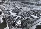
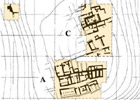
The tell is situated at the end of a kurkar ridge, c. 150 m from the northern bank of the Yarkon River and c. 1,750 m from the river’s outlet into the sea, on the grounds of the Eretz Israel Museum in Ramat Aviv. Settlement remains dating from the Iron Age to the Middle Ages were exposed on the tell. The excavations at the site were directed by Professor Amihai Mazar, on behalf of the Eretz Israel Museum, the Institute of Archaeology of the Hebrew University of Jerusalem and the Israel Exploration Society. The excavations at Tel Qasila were first begun by Professor Benjamin Mazar after two ostraca with Hebrew inscriptions dating from the time of the First Temple were found there. During 1948-1951 excavations, on behalf of Israel Exploration Society and directed by Benjamin Mazar, were conducted over an area of 1,200 sq. m in the southern part of the tell (Area A). In 1956 he also conducted an excavation of limited scope on the tell’s northwestern slope. Between 1971-1974 Amihai Mazar excavated an area covering c. 1,300 sq. m in the center part of the tell (the eastern part) where the sacred compound of the Philistine city (Area C) was revealed.
The excavations were focused on exposing the Iron Age I strata of the Philistine city (at its peak the city extended across an area of c. 16 dunams).
The great importance of the tell lies mainly with the finds buried in the Philistine layers. These strata are unique in their scope, preservation and the variety of artifacts that were discovered in them. The finds shed light on the Philistine culture and on a broad range of issues associated with its material and spiritual culture.
In order to fully appreciate the potential for presenting the site to the public at large, we examined a number of issues in each area including: data concerning the strategraphic finds; archaeological “clarity”; the state of preservation; architectural “clarity” and original building materials. The main emphasis was on the physical condition of the archaeological remains. The principal findings are presented below:
Area A
The built artifacts in Area A were uncovered more than fifty years ago. Over the years, the excavation area was attended to by the museum’s staff, which took steps to stabilize the remains, arrange access paths to the antiquities, maintain the antiquities and provide illustrations and presentations.
Physical Problems and their Causes
For the purpose of examining the problems and evaluating the finds, Area A was divided into six secondary fields. We can summarize by saying that improper conservation maintenance in the past and the lack of maintenance in the present have accelerated the physical deterioration of the finds (for example: the rampant growth of vegetation, the disappearance of bonding materials, walls falling apart, foundations that have been washed away, the solving of localized problems through the use of inappropriate materials and technologies). The problems that were evident in the field are:
Lack of Drainage – Levels and drainage have not been arranged. The run-off is not conveyed away from the archaeological remains; rather it collects in large puddles between them. The standing water dissolves the bonding materials at the bottom of the finds and creates a very moist environment that lasts for a prolonged period. The two phenomena endanger the finds by undermining the physical condition and hastening the destructive processes at the bottom of the vertical surfaces. Moreover, the standing water encourages the growth of vegetation.
Covering Vegetation – In the absence of maintenance, vegetation grows over and between the archaeological remains. The vegetation obstructs the finds; its roots crack them and promote the crumbling of the bonding material which leads to stones falling out of place and the general disintegration of the find. In addition, the vegetation fosters favorable conditions where insects and reptiles can reproduce, which constitutes a further cause for the acceleration of the destruction.
The Physical Problems of Kurkar Elements:
Crumbling at the Tops of the Walls –
The tops of the walls are directly exposed to mechanical damage by man, animals and the weather. Rain and hail dissolve and wash the bonding material from the walls. The processes of dampness and drying constitute another factor in the weakening and disappearance of the bonding material during which the physical adhesion between the stones in the tops of the walls becomes undone. When the stones are no longer held in place they start falling from the top of the wall as a result of undermining, touching, stepping, vegetation or any other disturbance. The roots of the vegetation, which penetrate into the finds, constitute another accelerating factor in the destruction of the bonding material and the breakup of the walls.
Disintegration of the Tops of Walls that are Treated with Cement Coping – In several places at the site the tops of crumbling walls were treated with cement used as a bonding material to hold the stones together and as a finish applied to the top of the kurkar walls. Cracks form at the interface between the two materials (the cement and the kurkar) because the cement is a strong inflexible material relative to the kurkar and the original bonding material. The cracking develops into fissures in those places where the cement is thin and/or where the stone is weak. This leads to the disintegration of the stone and the breakdown of the construction mass.
Crumbling at the Bottom of the Walls – Excavating below the elevation of the find’s foundation exposes the layers below it to undermining by water, crumbling and erosion due to mechanical damage caused by rain, surface water, standing water (puddles) and the daily processes of dampness and drying. These processes cause the foundations to retreat leaving the walls above them unsupported. As this process of gnawing away advances, it spreads to the area below the foundation and ultimately leads to the collapse of the wall.
Physical Problems with the Plaster Finish of Architectural Elements – The disintegration of plaster on the tops of restored walls is a direct result of damage caused by rainfall and the undermining of water. It is reasonable to assume that the use of incompatible materials caused the cracking and detachment of the finishing materials. The cracks provide an easy path through which the water can undermine and wash away the plaster finish. Mechanical damage and vegetation are a factor that promote and accelerate this phenomenon.
Powdered Decohesion and the Detachment of Finishing Layers – A characteristic phenomenon that stems from the capillary action of water and salt and the daily cyclical processes of dampness and drying. Lacunae form in the finishing materials and without maintenance they become larger, deeper and more acute. The process does not stop with the finishing layers; rather it continues into the core of the find creating deep internal deterioration of the building materials.
Collapse – Loss of the construction mass on the outside of the wall. This is caused as a result of two factors: (1) In an advanced stage in the weathering process of a mudbrick wall, when the outer envelope at the top of the wall is breached by a crack, erosion, mechanical damage or any other damage. The breach allows water to penetrate and a process begins whereby the wall is destroyed. The process produces a built mass the back of which is separated from the wall because of the mechanical damage and the undermining by the water. When the balance is disturbed, the mass slides from the wall and collapses. (2) Collapse as a direct result of mechanical damage.
In both instances the deficient morphology is an inverted pyramid. The triangle of missing mass is in the upper horizontal plane of the find from which the deficiency decreases down the vertical plane.
Physical Problems in the Restored House – The “Israelite” house in the middle of Area A was completely restored. Its walls were raised to a height of c. 4 m and a row of wooden posts was installed in its courtyard. A roof comprising layers of soil and tar was built on top of a wooden superstructure. Vegetation has grown across the entire surface of the roof. The walls were treated with plaster and several installations were restored in the house. In the wake of localized deformations and collapse an engineer’s opinion was sought regarding the structure’s stability. He determined that the house is in danger of collapse and it was therefore closed to the visiting public. Detached layers of the finishing plaster are visible inside the structure. This phenomenon stems from multiple layers of plaster made of unsuitable material that did not permit physical adhesion. The penetration of water into the structure is a factor that accelerates detachment such as this.
Deformation in the Walls – This phenomenon is caused following the use of incorrect building technologies (double faced walls without stone tie-ins, mixed bonding materials that do not create the necessary adhesion). Added to this is the factor of water penetrating into the structure.
Roof – The secondary beams in the roof are made of eucalyptus that was not de-barked before it was set in place. The bark serves as a platform on which insects can develop that gnaw away at the material, which can, in an advanced stage, result in its collapse.
The lack of maintenance causes the roof sealant to weather resulting in the penetration of water and deep saturation of the roof’s soil fill. Saturation of the soil creates an exceptional load on the system of secondary beams, which have buckled in several places.
Exterior Plaster – Cracks, crumbling and detachment are visible in the plaster as a result of an erroneous combination of technologies and materials. The lack of proper maintenance and climatic damage accelerate this phenomenon.
Mixing Methods and Building Materials – The weathering of the exterior plaster has exposed improper construction (from both a technological and material standpoint). This fact combined with dampness undermines the stability of the structure, which is manifested in localized deformation, crumbling and collapse.
Area C
The archaeological remains in Area C were uncovered some thirty years ago. The remains in this area have not been treated since their initial exposure. In this region there are excavation sections, remains of temples and buildings, walls, installations, roofing, fences, a minimal amount of posted signs and vegetation. The intervention in this area has included the installation of roofing, fencing, and minimal signposting.
Two main secondary fields were designated in this area:
C1 (the northern field) – The area of the temples – the covered area: the cultic center of the Philistine settlement, characterized by mudbrick construction. Most of the finds are covered by a roof.
C2 (the southern area) – An open area where there are kurkar and mudbrick building remains, an area with remains made of fired mudbricks; there are two roof coverings in the area. Until about two years ago the museum staff used to cover the area with canvas sheets in the winter.
The physical condition of the remains of the mudbrick construction varies from well-preserved to complete disintegration, in accordance with the extent to which they are protected by a roof covering. The roof coverings are antiquated and there are visible problems with them that are characteristic of the materials from which they are made (rusty metal, holes in the asbestos, blocked gutters). They have not been maintained. The kurkar built remains suffer from mechanical and climatic damage, disintegrating material and undermined stability. The overall present state of Area C is one of neglect that is hastening the destruction and disappearance of the archaeological finds.
Sub Area C1 - This secondary field was excavated during 1972-1974. The cultic center of the Philistine settlement was uncovered and it comprises an unusual stratigraphy of temples that is unparalleled in scope and level of preservation. Most of the buildings are mudbrick construction. Toward the end of the 1972 excavation season the Tel Aviv municipality assisted in erecting a temporary roof covering to protect the remains of the temples. This covering is what protects the finds.
A raised (“floating”) walkway was installed in the southern part of the covered area, above the remains of the temples; it allows one to view most of Area C1 and to the south of it, toward Area C2. The western wall of the roof covering (between the covering and the top of the excavation trench) is closed with wavy sheets of asbestos. Beyond the roof covering, toward the west and north, are shallow excavation pits and trees. East of the covering is another area that is the continuation of the excavation area. The area is fenced off and is bisected by a path running in the direction of the raised walkway.
The principal remains of the Philistine temples are located beneath the roof covering and to the north of the raised walkway. The exposed finds are actually structural elements from three Philistine strata whose current volume and shape are a result of the archaeological excavation.
Sub Area C2 – This area is partially covered. Located in it are the remains of wells, a bathhouse, public building and residential buildings from different periods. The finds in this region are constructed of a variety of building materials: kurkar in the walls and floors, mudbricks, fired mudbricks, and architectural elements made of hard stone.
The importance of this area is that it is a continuation of the settlement layout and that a large building paved with kurkar that is unique to its period was exposed here. This area is fenced off and one can see the finds from four directions, but one cannot walk amongst them. The archaeological finds are incomprehensible to those viewing them. In the southeast corner of the area, there is a low covering protecting mudbrick construction. The entire area is overgrown with vegetation.
Most of this area was excavated down to the level of Stratum X. Parts of finds from later periods that are cut off from their periodic context were left in the area. The southwestern corner of this area was excavated down to the level of the bedrock and we estimate that another meter or so is left of unexcavated remains from Strata XI and XII.
A careful study of the finds in the area, in coordination with the excavator, will provide tools for defining the secondary areas to be covered for the purpose of conservation and decreasing the areas requiring maintenance.
The Physical Problems and their Causes
As a rule it can be said that the absence of conservation intervention in the archaeological finds leads to the loss of the finds. The lack of maintenance at the site causes accelerated destructive processes and the deterioration in the physical condition of the exposed finds.
The Kinds of Weathering Characteristic of Mudbrick Construction:
Reticulated Cracking – A network of cracks on the surface, with no penetrating damage, appears as a result of the daily cycle of dampness and drying. Non-treatment will cause the disintegration of the wall surfaces.
The Disintegration of Mass – Is mostly present on the tops of elements and appears as crystals on the surface. This disintegration is a result of climatic changes (the daily cycle of dampness and drying) that causes the material to lose its natural properties of adhesion. This disintegration increases the surface area exposed to climatic effects, thus accelerating the destructive processes, which should they continue, will result in the find turning into columns of soil that will ultimately crumble and collapse.
Powdered Decohesion at the Bottom of Vertical Surfaces – This appears as a horizontal strip that becomes deeper inside the find. In most instances a smooth layer of crumbled soil will appear at the bottom of the strip.
This disintegration is a result of three factors:
- The daily cycle of dampness and drying cause the material to lose its adhesive properties, to erode and crumble.
- The dissolving of the material in the wake of water gathering at the bottom of the wall.
- Capillary moisture causes the daily cycles of dampness and drying to become more acute.
This phenomenon combined with the salinity that is present in the region greatly accelerates the disintegration of the material. Development of this phenomenon leads to the collapse of the entire built surface above the undermined area. The phenomenon also occurs at the bottom of the archaeological excavation sections and as a result of excavating below the level of the wall foundations.
Damage Caused by Animals (insects, rodents, reptiles and birds) – deep recesses in the material: nesting holes, burrows etc; creating kinds of honeycombed nesting inside the soil of the find; animal droppings on the tops of the remains; widening existing cracks; burrowing and digging into horizontal surfaces or at the bottom of vertical surfaces.
Water Erosion – Deformation of the shape of the find as a result of the direct flow of water washing across the material. This phenomenon, if not treated and prevented, will result in the dissolution of the find.
Detached Stones – A phenomenon caused by the weathering of the material as a result of climatic conditions or mechanical damage caused by man or animals.
Development Defects – The development work has caused physical and visual flaws to the finds. There is mechanical damage having resulted from nailing signs into the earthen finds. This action causes cracks to develop over time, followed by the disintegration and detachment of sections of wall.
Covering cement foundations with kurkar slabs is a visual defect. In this instance the material matches the original; however, the size of the stone that was used, how it was arranged and the construction method employed are all incompatible. A cement foundation that was poured on top of a mudbrick wall without a layer separating it from the mudbrick constitutes an engineering and visual defect.
The Weathering of the Original Finish Layers– Disintegration, falling off and disappearance of the original finish layers is caused by changes in climatic factors (daily cycles of dampness and drying), mechanical damage by man and/or animals and the lack of proper maintenance.
Previous Intervention at the Site - includes sections of restored walls, completed stonework and grouting and the tops of walls that have been covered with bonding materials or kurkar gravel stand out in Area A. The sections where the intervention occurred are not marked with restoration lines and we have no documentation regarding them. In its current state we cannot clearly distinguish between those finds that are original, treated originals, completions or restorations. The methods used to stabilize the remains were neither methodically nor systematically applied. They consist of completing and restoring walls using mudbricks and kurkar and/or piling up soil combined with kurkar and/or soil with the addition of cement and paint the color of plaster. The construction involving restored finishing plaster is mainly concentrated in the northern row of buildings. Based on its appearance, we can assume that this restoration/treatment was done so that it would resemble the mudbrick construction. Most of the tops of the walls are also plastered, something which is misleading, in that it fosters the impression that the remains are actually very low walls. A complete restoration of one of the residential buildings was done mixing materials and technologies. In several places the intervention is apparent where cement was used as a bonding material to stabilize the walls. Wooden posts that are used to support awnings in the restored house bisect the interior of it.
The perimeter of the large kiln was restored using silicate bricks.
In Area C, other than the installation of roof coverings, no conservation intervention was carried out on the finds themselves. The intervention in Area C1 consisted of reinforcing the roofing and walkway with cement and steel. In Area C2 the intervention involved reinforcing the roofing with wood and steel.
The recommendations for conserving the site and presenting it to the public are twofold, involving immediate treatment of the weathering factors and future treatment in which conservation intervention will be a component in the overall plan for the site.
The immediate action that is required at the site includes treatment of the physical problems and the different factors that promote destruction. The essential measures that need to be taken are: arranging drainage; stabilizing the excavation sections; removing vegetation, preventing damage caused by vegetation and animals; stabilizing elements in danger of collapse; completing finishing materials and sealing the tops of walls. Delicate treatment of the mudbricks finds located beneath the roof covering: restoration of the mudbrick finds that are exposed to climatic damage (beneath the edges of the roof covering); identifying areas that need to be covered; general treatment of the restored house. Treatment of the roof covering: treatment of leaks, treating material weathering.
The future treatment will be part of an overall plan and the manifestation of the vision for the site. It entails drawing up a multi-year, phased plan of action for explaining, presenting and operating the site. The planning will be based on the general concept of the site and take into account its proximity to the exhibition building that will be constructed nearby. The conservation plan will include preparing visitor paths, roof coverings, conservation, restoration and development, ongoing maintenance of the site and the training of personnel to implement this. At the same time presentation planning is required, as well as a guide plan to direct the public that will include approaches, signs, explanatory materials and operating plans.
To view the figures, click on the figure caption
|
|