| Tel-Aviv – Jaffa |
| Old Jaffa |
| Mazal Dagim St. Preliminary Documentation of Buildings 1, 3, 5 |
| Duration | October 2013 |
| Address | Block 7040, Lots 131, 132 |
| Implemented by: |
Arch. Faina Milshtein
Arch. Hila Berger On
|
When the rehabilitation of Old Jaffa was begun in the late 1960s some buildings were converted to commercial use. Changes were made to both the interiors and exteriors of these structures in order to adapt them to their new use.
The block of buildings on Mazal Dagim Street is owned by the Jaffa Development Company. In 2009, the Engineering Department of the Tel Aviv-Yafo municipality issued a closure order for the complex because it was too dangerous to be used. In 2012 all use of the block was halted and it was closed.
In the wake of the development initiative, a documentation file on the building was prepared on behalf of the Israel Antiquities Authority and recommendations and guidelines for the conservation of the structure were submitted.
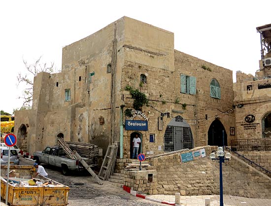 General view of the complex, 2013
Location and Surroundings
The block, which is part of the Armenian monastery complex, is located on the southwestern slopes of Tel Yafo. Buildings are adjacent to its northern and western sides, Mazal Dagim Street passes to the south of it and the Kedumim pedestrian mall is to its east. The site was designated for preservation, and the uses permitted in it were defined in Municipal Building Plan 606A from 1987. The conservation aspect of the plan banned any construction work other than essential maintenance meant to ensure the stability and safety of the structure.
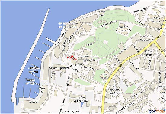 Orientation map
Historical Background
The complex of buildings was probably constructed in the first half of the eighteenth century and was restored in the Late Ottoman period during the building and rehabilitation boom that Jaffa experienced. The block appears on the historical alley on the Sirkin Map from 1842 and Theodore Sandel’s map from 1878. On these maps we can see the urban development of Jaffa outside the Old City walls at a time when some segments of the walls were destroyed, the moat was filled in and turned into a main road which is today Yefet Street.
The army entered the city in 1917, during the early days of the British Mandate. The rapid expansion of the Jewish community in Jaffa at this time provoked riots by the Arab residents who felt hostility toward the new population. In 1936, the British conducted extensive demolition measures dubbed “Operation Anchor” for the purpose of restoring order. During the course of the operation 236 buildings were destroyed. These actions resulted in much destruction, but also led to the creation of roads and reduced the level of congestion in the city.
In September 1949, following the War of Independence, the Tel Aviv municipality began the systematic demolition of the Old City for security reasons and urban planning. It was then that the part known as “Gan Ha-Pisgah” and other smaller areas were torn down. These measures were halted after a short period thanks to Shmuel Yeivin (Director of the Department of Antiquities) and the artist Marcel Janco, who wanted to preserve and develop the historic urban fabric. In the 1960s approximately thirty percent of the historic built space remained habitable. With the destruction and neglect the space became a crime-ridden area where prostitution and drugs prevailed, and was given the nickname "the Great Area".
With the creation of the "Old Jaffa Development Company” in the 1960s Old Jaffa was designated an “architectural reserve” in Municipal Building Plan 606. Consequently, a policy was drawn up for the rehabilitation and reconstruction of buildings in the Old City in order to attract a new population to it and convert the "architectural reserve" into a center for tourism, entertainment and art.
In 2006 the Israel Antiquities Authority produced a policy paper regarding the Old City of Jaffa in which Tel Yafo was declared a protected antiquities site.
Changes that have Occurred in the Buildings over the Years
The complex originally consisted of two buildings that had inner courtyards. The structures were built next to each other and faced two alleys, one of which is Mazal Dagim Street. The building located at 1 Mazal Dagim Street was a two storey structure with five domes; a tile roof was built above one of the domes. The building located at 3-5 Mazal Dagim Street was a single storey structure and had a flat roof; a building addition was added onto part of it. The ground floor consists of cross-vaults; its walls are built of kurkar and are about one meter thick.
The building at 1 Mazak Dagim Street bears evidence of the two waves of destruction that struck Old Jaffa in the modern era: part of the western end of the building was demolished in Operation Anchor and in 1949 further damage was caused to that part. What is today the front facade was originally an inner facade. The courtyard that faces Kedumin Square was originally an inner courtyard, typical of the construction in historic cities.
A comparison of aerial photographs taken in 1946 and 2005 shows the changes in the structure: the tile roof in Building 1 was removed and replaced with a concrete parapet; changes were made to the partial storey on the roof of the building at 3-5 Mazal Dagim Street.
In the wake of changes to the surrounding area the central location of the complex made it a desirable location for businesses. Its modifications for various uses resulted in changes being made to the entrances in the building. Some of the openings were sealed and new openings were breached in the southern facade that faces Mazal Dagim Street. The structure has become a landmark in the built fabric that was preserved. The building, which was part of dense and continuous construction, became a corner edifice that defines an open urban space along the central boulevard leading from Kedumim Square to the Bet Mayumana car park. As a result of the destruction the inner courtyard of the original building became an open and inviting urban space.
Thanks to the attractive location and the building’s potential uses a number of physical changes were done to its interior and exterior: new openings were breached for display windows, walls were demolished, toilets were added etc. The ground floor was used for shops, a museum and a café, while the restaurant that was run for many years on the first floor was closed in 2012.
An Appreciation of the Site’s Importance
Cultural archaeological value – the buildings are located in an area that was used for thousands of years, from the time of the Middle Bronze Age, and since then it has been inhabited continuously until the present.
Historical value – the building is a testament to the changes that have taken place in Israel. The waves of destruction have left their toll on the structure. The changes in the surrounding areas altered the urban context of the building and today it faces the main road and Mazal Dagim Street.
Architectural value – the dense urban fabric of Jaffa, like that of Israel’s other historic cities, is a testament to the urban construction that was common in previous periods. The block is part of the built urban mass of Old Jaffa. Despite the waves of destruction it still maintains the route of the historic alley, as documented on the historical maps and old aerial photographs.
Architectural elements typical of construction in Jaffa in different periods were preserved in the buildings: double window openings with stone ornamentation, niches and arches, a wooden-rib ceiling and a wide dome adorned with plaster impressions.
Engineering Survey and Recommendations
The documentation file did not include an engineering survey; however, the building is stable despite the destruction it has experienced. Trial excavations conducted in the neighboring buildings revealed they were erected on remains from the Hellenistic and Roman periods; hence it can be assumed that is also the case with regards to this particular block.
Recommendations for the preservation and rehabilitation of the structure require, among other things, that all future rehabilitation work maintain the present construction line facing Pasteur Street and Mazal Dagim Street; the features of several adjacent buildings be preserved; no additions be constructed on the roof of Building 1 so as not to disturb the existing balance between the building mass and the surrounding open space; the rehabilitation of the facades be done utilizing traditional building technologies; the cable and wire infrastructures on the facades be covered and the inner courtyards remain open, without any building addition.
References
Aerial Photograph Collection, Department of Geography of the Hebrew University of Jerusalem.
Gera A. 1995. History of Jaffa. Israel Antiquities Authority and the Old Jaffa Development Company (Hebrew).
Kark R. 1984. Jaffa—A City in Evolution, 1799–1917. Jerusalem: Yad Izhak Ben-Zvi (Hebrew).
Shiller E. (ed) 1981. Jaffa and its Sites, Qardom 15. Pp. 24–39, 60–68 (Hebrew).
The Old Jaffa Development Company Archive – Building File (Hebrew).
Tel Aviv-Yafo Municipal Archive – Building File (Hebrew).
Tolkowsky S. 1926. History of Jaffa. Dvir Press, Tel Aviv (Hebrew).
To view the figures, click on the figure caption
|