| Jerusalem |
| Lifta |
| A Preliminary Urban Survey |
| Orderer | Emeq Ayalon Company |
| Duration | July 2008 |
| Implemented by: |
Arch. Avi Mashiah
|
In 2003 archaeologist Jon Seligman and architect Shahar Puni conducted a survey of selected antiquities sites for the Municipality of Jerusalem. The survey focused upon archaeological sites in the New City and was published as an appendix to the master plan (Report No. 4 in the Jerusalem Local Plan 2000). The remains of Lifta village were included in the survey which states that these building remains are a very important example of traditional construction in the Ottoman period. The survey also notes that within the village precincts are the remains of a rectangular building (16.4 x 18.2 m) whose front is made of stones with drafted margins; the building was probably used as a farmhouse during the Crusader period and an ancient olive press was exposed in it. In addition, hewn burial caves, rock-hewn funerary installations in which ossuaries were found and remains of terraces in the river channel that date from the Iron Age onwards were surveyed. The conclusions of the survey, which as previously mentioned were included in the master plan, recommend that the proposed development should incorporate the ancient remains in an appropriate manner. It was also noted that the overall environmental context of the site, which is located on the slopes of Nahal Soreq, should not be destroyed by paving roads or construction that is not in keeping with the character of the existing landscape.
http://antiquities.org.il/images/archinfo//001-030/028.pdf
Plan No. 6036 for the Development of Lifta (Mei Niftoach) was validated in August 2006. Lifta was classified a nature reserve in previous plans from 1959. The new plan designates the land for the construction of 268 dwelling units on an area of 456 dunams that will incorporate commerce, public development, hoteliery, institutions and new access roads. This development, which is subject to the current transportation and safety requirements, is anticipated to have a dramatic effect on the village’s precipitous landscape.
The aim of this survey was to map the remains of the village and identify which urban and architectural values were preserved there and to create an up-to-date data base in order to formulate guidelines for the protection and development of the site.
The village of Lifta is situated in what is today the western entrance of Jerusalem, at an elevation of 650-730 meters above sea level. The village is located on a steep slope above Nahal Lifta, which is Nahal Mei Niftoach. Archaeological remains of the settlement Mei Niftoach, which dates to the First Temple period, were found in Lifta. This settlement is mentioned in the Bible, in the Book of Joshua, as the northern border of the Tribe of Judah. The village was destroyed during the Roman invasion led by Titus Flavius Vespasian.
During the Byzantine period a settlement by the name of Nephtho was located there and in the Crusader period there was a village called Clepsta, from which an impressive building has survived near the village core. In the sixteenth century the village was inhabited by c. 400 occupants and its population increased gradually.
The first settlement in the village was near ‘Ain Lifta. This is a sealed perennial spring in which there is a 60 meter long tunnel that conveys the water to a large reservoir. The spring water flowed from there to two pools and irrigation channels extended from the lower pool out into the fields. Although from a climatic standpoint it is advantageous to settle on the southern and eastern bends of the ridge, the village developed along the western bend, from which there is a broad and convenient vantage point that looks out over the farmland.
The village reached its zenith toward the end of the nineteenth century and it is described in articles of the period as the largest Arab village in the region. Its land extended as far as the neighborhood of Mea She’arim, Schneller, Sharei Hesed, Sheikh Jarrah and Ein Karem. The construction of the new Arab and Jewish neighborhoods in its vicinity entailed the purchase of land from the village.
The population of the village grew during the British Mandate. The modernization processes led to changes in the villagers’ lifestyle. These were manifested, among other things, in the construction of houses on farmland, which were scattered and lacking uniformity. One can thus recognize changes in the structure of the traditional village – changes in the shape of the houses, the technology and in the construction details. In 1948 approximately 2,700 people lived in the village of Lifta.
During the 1948 war the village served as a base from which attacks were launched against the Jaffa-Jerusalem road and the Jewish neighborhoods. Lifta was abandoned in February 1948 after the Lehi carried out reprisal raids in the Romema quarter and along the fringes of the village.
Since the creation of the State of Israel various development plans have been proposed that were meant to safeguard the character of the place. It has been suggested that a residential neighborhood that would draw inspiration from the traditional village fabric be established there, together with a small industry zone, education campus and even a national center for nature, landscape and the heritage of man in Israel.
Due to the high development costs, the sensitivity of the landscape there and the complexity of the treatment of the ruinous stone buildings, none of these plans were implemented and over the years the village remains have turned into a refuge for squatters and the homeless. Even so, the village’s location at the bottom of the slope, the difficulty in getting there via modern transportation and the absence of development have all contributed to preserving the original characteristics of the abandoned village.
Today the remains of the village are surrounded by a network of urban roads:
• From the south: Highway 1 – the historic road from Jaffa to Jerusalem and the teeming entrance to the city at the Giv‘at Shaul interchange.
• From the east: Derekh Begin which separates the houses of Lifta village from the neighborhood of Romema Illit, located on the slope above.
• From the north: Highway 9, a new road that passes through the Ererzim Valley, links Moza with Derekh Begin and from there to French Hill. The houses in Lifta village can be seen from this road. Today there is a steep footpath that passes through the center of the valley which connects the Giv‘at Shaul interchange, by way of the houses of the village, with the Erezim Valley (the path is marked blue by the Nature Preservation Society).
Urban Description
Lifta village first began to develop as a settlement in caves on a precipitous slope, 300 meters north of the spring and along the same contour line. The available living area was enlarged by constructing crude fieldstones and mortar walls with very small openings incorporated in them. As the family got larger other stone buildings were erected that formed a defensive block around an inner courtyard. This block, which reflects the family values at the time, provided basic protection against external dangers.
Gradually the village expanded and a crowded core of five blocks took shape in it, a block for each extended family that resided in the village. The small houses, which developed in an organic fashion, were built next to each other. The blocks developed inward – within the precincts of the block. The residents would meet in the center of the village, in a protected open space located in the middle of the residential blocks. It should be noted that olive presses and small flour mills for personal consumption operated in the village, which reflect the village’s economic independence.
The increase in the level of security and the standard of living, and the industrial and agricultural progress from the middle of the nineteenth century are evidenced in the growth of the village core and the construction of larger houses, next to each other, most of which have two stories. The upper stories are characterized by wide openings and elements such as a fireplace in each room and ceiling decorations.
In the 1870’s the village began to spread out on the path that led toward the spring and further along the path that exits the village to the north. The defensive component in these houses still determined their fortified shape. It is true they were built as a single two story house on a separate plot of land, but a stone wall was constructed around the and the ground floor was characterized by small closings and openings.
A main road crossed the village from south to north. Alleys, which branched-off up or down from the main road, led to the private spaces of the residential blocks. Thus a gradual transition was created in the area between the public and private domains and vice versa. A mosque was built along the main road, on the edge of the village core, and a guest house was established next to it.
By the beginning of the twentieth century, with the increase in the standard of living and a sense of personal security, the village continued to expand beyond the western bank of Nahal Lifta and farmhouses were built in which the influences of urban construction are evident.
Architectural and Technological Description
The typical aforementioned residential buildings have been preserved until now in Lifta.
The traditional rural house. This is the basic unit that makes up the residential blocks which was widespread in the villages of the hill-country until the end of the nineteenth century. This is a single room, without partitions, and is divided into levels in accordance with the various functions that were carried out in the house:
• Rawiyeh – a bottom level at the elevation of the courtyard which is considered the “dirty” part of the house. It was used for storage and where livestock was sheltered.
• Mastabeh – A higher residential level where all of the inhabitants’ activities were conducted: sleeping, eating, hospitality and storage.
• Gallery (Sida) – another living surface raised above the mastaba, which was used primarily for sleeping.
The Expansion of the Traditional House. In the second half of the nineteenth century a residential story that is characterized by a cross-vault was added above the traditional house. Thus a complete separation was created between the floor with the livestock in the bottom room and the residential story, and a separate entrance was installed in each story.
“Fortified” Houses. These houses were built outside the village core and were characterized by two stories: a raised ground floor that had tiny openings which was used for raising animals and storage, and a separate residential floor in which there were large openings and balconies. South of each building there is an expansive courtyard with a small structure in it that was used for storage and a tabun was sometimes located inside it.
Farmhouses. The first use of modern building technology is evident in the farmhouses. Iron beams were used in their construction and the roofs were made of concrete and roof tiles. These structures have balconies with a view and wide doorways.
Modern Houses from the Time of the British Mandate. A strong urban influence is apparent in this construction which is characterized by the use of concrete, flat roofs, regular rectangular doorways and painted floor tiles.
The pressure of development in the country’s Arab villages and the use of modern building technology led to the destruction of the traditional homes such as those that were preserved in the core of Lifta village. This building tradition, which characterized hundreds of years of traditional rural construction, is therefore in danger of disappearing.
Heritage Evaluation
The Urban Value
The village of Lifta has been preserved as a traditional fabric that reflects the political, social and economic changes which have shaped the region during the past four hundred years.
The urban characteristics that were preserved in Lifta are:
• A hierarchy of roads that runs through the village and its environs and defines the relation between the public and private domains: a main road aligned in a southeast-northwest direction; a main street that runs from south to north with squares and public areas along it; an alley that is closed at one end and an entrance to a residential block.
• Typical hilltop landscape that is characteristic of the traditional Arab city in the hill-country and Shephelah, as it developed over the course of hundreds of years.
• The entire fabric of rural building (vernacular architecture) has been preserved, which developed spontaneously.
• A skyline that follows the topography and intensifies the integration of the village’s houses in the landscape.
• Incorporating the construction on the terraces which were used to prevent erosion and for cultivation.
• The cadence of the building components, thanks to the uniform size of the basic unit and the dimensions of the openings.
• Preservation of the traditional flora of the Arab settlement in the hill-country: the hedgerows of sabra plants that delimit the plots, the remains of ancient orchards on farming terraces in the vicinity of the village and the olive groves in the valley.
• Public meeting places and public buildings: a mosque, guest house (hamdafa), the spring and reservoir.
• Four clan-owned, public and private olive presses.
• The division into household blocks of extended families and their characteristic components:
1. The alley is separated from the courtyard by a fence and gate.
2. A private courtyard is shared by the clan members and one passes through it when entering into the residential units.
3. There are shared elements that are located in the courtyard such as a cistern, tabun and staircase that ascends to the roof.
4. Private entrance balconies that replaced the courtyards of the extended family.
5. Privacy is maintained by preventing direct visual contact between the courtyards and between the alley and the courtyard.
Architectural and Technological Values
In Lifta five types of buildings were identified that were preserved and reflect the spirit of the period and the evolution of the village. In all of them traditional architectural characteristics were preserved that reflect a period and culture. As stated previously, these are in danger of disappearing. The concentration of these very characteristics in Lifta makes the village remains unique compared with all the other villages in the country thanks to the absence of development within its precincts.
Architectural Characteristics that have been Preserved:
The House Courtyards. The central courtyard, which was a transitional region from the alley to the house and a meeting area for the clan, was preserved in different variants. Generally speaking we are able to identify a courtyard belonging to an extended family which is shared by a number of houses and connected to an alley in a variety of ways. Likewise, it is also possible to identify private courtyards which belong to nuclear household units. The shape of the courtyard and its function were modified with the changes that occurred in the village. It only served the private house and later appeared as an entrance balcony that controlled the surroundings. In some of the courtyards it is possible to discern traditional elements such as the stone wall and gate that link the courtyard with the alley, as well as the tabun and cistern that were used by the entire family, and raised surfaces for sitting that are located for the most part on the natural bedrock.
The Roofs. The roof of the house served as an open area for the use of the residents. The roofs were used for sleeping during the hot summer nights and raising pigeons and bees. Dovecotes that were incorporated in the upper courses of stonework can be discerned in some of the residential blocks.
The roof was reached by means of a ladder that reached a number of steps which led to the roof. Over the years the use of the roof was made more accessible by the addition of cantilever steps, stone steps and prefabricated concrete steps that were built next to the building’s façade.
The early houses were built as barrel vaults; later they were built as cross vaults which were prevalent throughout the village. The vaults were covered with leveled layers of soil and lime and formed the surface of the roof. In the later houses one can even discern flat roofs and tiled roofs.
The building envelope changed with the development of the village, from a closed jumbled facade in which there are small functional openings to facades that were influenced by the urban Arab house in which there are several groups of decorated openings, different forms of stone dressing and an exit to cantilevered balconies.
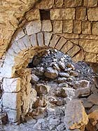
Openings. In most of the doorways in the entrance to the buildings one notices a massive lintel beam with a relieving arch above it. These exist in many variations.
The windows evolved gradually from a small opening that was the width of the building stones and the height of the stone courses to wide windows such as the double window that was prevalent in Arab construction or the triple arched window (trifor) that characterized the central hall house in the cities.
The floor of the house was mostly built of tamped soil which was replaced over time with a ‘meda’, that is, lime-based mortar and soil, and later with flagstones and decorated tiles. Sometimes all of the different kinds of pavement exist in a single structure.
The Interior of the House. In most of the houses traditional components were preserved inside the house such as a hearth, chimney and niches that were used for storing the contents of the home. The niches for the bedding were all built the same width which probably stemmed from the width of the mattresses. In the later and larger houses a hearth was built in each of the rooms and to heat the very large rooms they sometimes built two fireplaces. In two of the buildings the remains of large clay silos used to store agricultural produce were preserved; these were built as a partition in the middle of the hall. Plaster floral decorations are still visible on some of the buildings’ walls and their ceilings.
Evaluation of the Physical Condition
The destruction caused by the war in 1948 and thereafter in the 1950’s damaged the urban fabric of the village and the uniqueness of the village core. The intentional destruction of the roofs of the buildings and prolonged neglect of the place led to the decline in the physical condition of the houses in the village.
The early phase of settlement around the caves was severely damaged due to the poor quality of the construction that characterizes it. Only a few walls remained standing and a number of original houses remained in situ.
There is a considerable amount of destruction in the village core; nevertheless, it is still possible to identify the urban fabric comprising the alleys and the buildings. In many instances the empty space was interrupted and severed by collapse and parts of buildings. The blocks that are located south of the main square are in a better state of preservation than the blocks to the north of it. There are buildings among the structures that are part of the expansion of the village core; these survived in a relatively good state of preservation thanks to the quality of the original construction. Entire blocks of buildings were preserved there, including courtyards and alleys. All of these bear witness to the development of the village, and the different construction phases can be identified in them.
The buildings from the phase when the village first expanded toward the north were completely destroyed and the urban fabric was eradicated. The buildings and their courtyards to the south, on the way to the spring, are partly preserved intact; however, one can still experience walking along the main road alongside the village wall.
Some of the walls of the buildings were preserved in the farms on the western bank of the Nahal Lifta but the roads that led to each farm, which have not been used for years, have long since disappeared.
Summary and Conclusions
The remains of Lifta village at the western entrance of Jerusalem are a last piece of history of the lifestyle and of the traditional building culture. This village, whose origins were mentioned already in the Biblical period as the boundary of the territory of the Tribe of Judah, is a living memento of the ancient landscape and the indigenous building that was prevalent throughout the country for hundreds of years – traditional construction that is integrated in the environment: in the features of the bedrock, nature and topography.
Lifta is a preserve of popular architecture (by and large vernacular) and of rural construction that developed in an organic manner. The preservation of the village’s buildings stems from its years of isolation since the establishment of the State at which time it was abandoned. The development process, which froze in Lifta, distinguishes it from villages where the habitation continuity and modern construction technology have obscured the core structure of the village and its phases of expansion.
Development that is oblivious to the value of the place and the conversion of the village core into modern residences are liable to severely harm the delicate urban fabric, the connection of the village to its environment and the traditional construction that has been preserved there.
An examination of similar test cases in Jordan and Mexico where abandoned historic villages were adapted for modern use shows that the success of the rehabilitation of the village depends on leveraging the original values of the place and on minimal modern intervention in the environment. In both instances the region was developed as a focal point for experiential tourism, a use that does not necessitate intensive development.
As previously mentioned, three main development phases can be discerned in the village:
1. The establishment of the village core in three development phases.
2. The break-out from the village core along the roads that lead to the village.
3. The expansion of the village along the western bank of the Nahal Lifta.
The village’s original network of roads is preserved in its entirety. The village sat on a secondary route that led west from Jerusalem in Nahal Lifta, by way of Lifta spring. In the square where the mosque is located this main road turns west toward the valley; whereas the village’s main street, which is parallel to the contour lines, continues to the village core. These roads, which served pedestrians and pack animals only, utilize the bedrock and the terraces as natural platforms.
The division of the area inside the village into residential blocks used by the extended family is still apparent; these blocks are surrounded by courtyards and create the urban fabric that includes a main street, alleys and squares.
Among the village buildings one can identify structures that are of special value such as the religious buildings, olive presses, the remains of a Crusader building and different variants of the central hall building made using traditional rural construction.
The survey recommendations were formulated with the intention of preserving the urban and architectural values of the place. The principal recommendations are as follows:
1. Each of the village’s development phases will be properly expressed in the conservation planning and development.
2. The historic boundaries of the village core will be emphasized and a buffer zone will be defined between it and the new construction surrounding the core.
3. An effort will be made to preserve the characteristic skyline of the village which follows the natural topography.
4. The division into residential blocks, which stemmed from the distribution of the households and the hierarchy of the roads and squares, is fundamental in preserving the original format of the village.
5. It is extremely important to preserve the original routes of the roads and alleys and preserve the surface level and its hierarchy.
6. It is recommended that a building survey be conducted in which structures will be identified that represent the development phases of the village, reflect the lifestyle in it and the architectural and technological values of the traditional construction. This survey will aid in determining the treatment of the architectural heritage.
7. Intervention in the traditional construction in the village will be done using cubic structures, c. 5 m long per side, which stems from the size of the vaults that were frequently used in the traditional construction, and will integrate with the characteristic domed roofs.
8. Modern infrastructures will be installed in a concealed manner that does not harm the landscape.
9. The new intervention will be clearly distinguishable from the original construction.
10. The features of the natural ground will be preserved and quarrying the bedrock will be limited. Leveling an area for construction will be done by raising the surface rather than by rock-cutting.
11. The details of the new construction will be based on the original building details which are characteristic of this compound, while maintaining the original architectural components, including: the niches, openings, steps, fences, tabuns, hearths and clay silos.
List of References
Amiry Suad, Tamari Vera 1989. The Palestinian Village Home. London.
Avitsur Shmuel 1972. Everyday Life in the Holy Land in the Nineteenth Century, Tel Aviv (Hebrew).
Avitsur Shmuel 1976. Man and His Work: An Historical Atlas of Tools and Workshops in the Holy Land, Jerusalem (Hebrew).
Canaan Taufik 1933. The Palestinian Arab House, Its Architecture and Folklore. Jerusalem.
Fuchs Ron 1998. The Palestinian Arab House Reconsidered. Part I. Cathedra 89, Jerusalem (Hebrew).
Hirschfeld Yizhar 1995. The Palestinian Dwelling in the Roman – Byzantine Period. Jerusalem.
Kertesz Goby 2004. Plan No. 6036, Jerusalem Local Plan, (Hebrew).
Kroyanker David 1985. Jerusalem Architecture – Periods and Styles. Arab Buildings Outside the Old City Walls. Jerusalem (Hebrew).
Moshe Michal 2000. The Village and the House in Lifta – Architectural Development and Processes of Change: A Study Camp, Hebrew University of Jerusalem (Hebrew).
Moshe Michal 2002. Architectural Formats in the Village and the Rural Arab House in the Judean Hills: Lifta – A case study thesis supervised by Professor Ruth Kark, Hebrew University of Jerusalem (Hebrew).
To view the figures, click on the figure caption
|
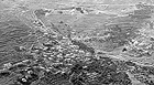 |
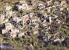
1. Aerial photograph of Lifta indicating the development phases of the village (courtesy of Albatross Aerial Photography, Ltd.).
|
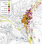 |
2. The development phases of the village as indicated on a Mandatory map from 1936 (without scale).
|
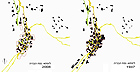 |
3. The construction volumes in Lifta from 1947 and today.
|
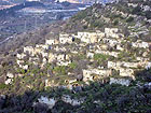 |
4. The houses in Lifta village, looking west, photograph: Avi Mashiah.
|
 |
5. The village core, looking west, a drawing of the cadence of the original volumes.
|
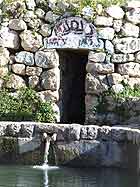 |
6. ‘Ain Lifta, photograph: Yael Rosenthal.
|
 |
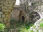
7. An alley in the village, looking from east to west, photograph: Avi Mashiah.
|
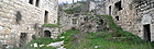 |
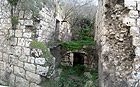
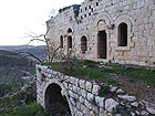
8. A preserved courtyard of a residential block, photograph: Avi Mashiah.
|
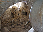 |
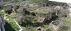
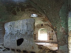
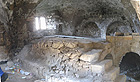
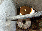
9. Remains of a large olive press, photograph: Yael Rosenthal.
|
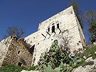 |
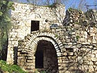
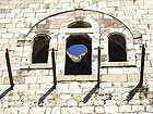
10. A typical “fortified” building. Photograph: Yael Rosenthal.
|
 |
11.
|
 |
12.
|
 |
13.
|
 |
14.
|
 |
15.
|
 |
16.
|
 |
17.
|
 |
18.
|
 |
19.
|
|