| Jerusalem |
| The New City |
| Survey of selected antiquity sites in the New City. An appendix to the master plan (Report No. 4 in the Local Master Plan, Jerusalem 2000. |
| Orderer | The municipality of Jerusalem |
| Duration | January-December 2003 |
| Implemented by: |
Arch. Shachar Puni
|
The purpose of surveying the archaeological sites in Jerusalem was to create an up-to-date archaeological data base that is available to the general public and professional planners, as part of the new master plan. The survey examined conservation, environmental and geographic issues, and conclusions and recommendations were drawn up for preserving and developing each site.
The Surveyed Site and its Boundaries:
The work was conducted within the municipal borders of Jerusalem, exclusive of the area in the Old City. The land in the surveyed area is being used for a variety of purposes; there are built-up areas and open areas and areas that are slated for construction.
“Special Antiquities Sites”:
Because of the characteristics of the city’s urban development and economic constraints, it is not possible to present all of the archaeological sites to the public. Therefore, it is of great importance to identify the sites slated for conservation and exhibition in situ, and those that will be preserved and maintained without being displayed to the public.
Selecting the Sites
There are 1800 sites in the Jerusalem area that are registered in the data bank of the Antiquities Authority. Some 550 of them are located in the Old City. At some of the sites only rock-cuttings are discernable, whereas others are monumental such as the Temple Mount.
During the course of the work we had to determine which of the sites, in our opinion, are of high cultural value. Without doubt, the Old City is the most important site in Jerusalem. It was clear that this should be treated separately. It was therefore decided that the appendix will include the sites that are located outside the Old City walls.
Criteria for Evaluating and Selecting Sites:
In order to make such a choice it was necessary to establish criteria that can be used as a tool in identifying the most important cultural assets for conservation and exhibition. The steering committee of the Antiquities Authority selected 120 sites which are approximately ten per cent of all the sites in the New City.
The criteria guidelines were:
- Period – these are the sites that are most representative of their periods. We felt it was important that every period be represented.
- Rareness – sites that should be preserved as a unique component in the diversity of the cultural heritage.
- Documentation – sites in which the documentation or historical literature describing them is itself important.
- Group – sites whose value is based on their connection with a certain assemblage.
- Preservation – the level of preservation of the site.
- Archaeological potential – a site where there is a high potential for exposing archaeological finds in the future.
- Science – sites that are extremely valuable because of their research importance.
- Culture – sites that are of religious or cultural importance.
- Technology – sites that represent technological development.
- Vulnerability – sites that are at risk of damage owing to their geographic location or due to the state of preservation of the material.
Examining the Sites according to Selected Criteria:
The results of the examination of the special sites are presented according to four criteria in the introduction to the report:
Kind of find: ruins, monasteries, industrial installations, city wall remains, water systems.
Conservation and maintenance: the necessity and the degree of urgency to carry out conservation work.
Environmental context: a basic division of the sites according to their environmental context.
- Sites where the finds are inside a covered structure.
- Sites where the finds are inside a closed compound (but situated out in the open), in a private area or area operated as a tourist site.
- Sites located in open areas in the midst of the urban fabric, sites that are not defined or are defined but not maintained on a permanent basis.
- Sites located on the fringes of the urban fabric.
- Sites in an open area and sites of traditional agricultural.
Tourism: the kind of visit, both those that take place and those which are expected to take place after the site is developed, such as Christian pilgrimage, visiting the site within the framework of an outing in an area of open landscape.
Contents of the Survey Card:
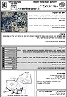
1. Geographic and Statutory Details
Name of the Site: the name of the site according to the Hebrew text appearing in the archaeological survey that was conducted in Jerusalem. Also along side the Hebrew name is the foreign name as it appears in the “Survey of Jerusalem”.
Other names: additional names, the Arabic name (in the event the site has one), popular names.
The site number: the sites were numbered for the purpose of the survey according to their geographic location from north to south.
Map reference: the map reference according to the old Israel grid. The map reference was designated according to the “Survey of Jerusalem”.
Block: block number (in the municipal building plan, according to the data bank of the Antiquities Authority [Menorah] ).
Declared antiquity site: according to the definitions of the Antiquities Law 1978, Section 1(3): “Antiquities Site” – an area containing antiquities which the administration announced according to Section 28(A’). This announcement is published in the Bulletin of Government
Publications (“Yilkut. Hapirsumim”).
The Antiquities Authority: the number of the site in the inventory survey of the Antiquities Authority.
2. The Environmental Context
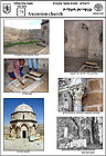
The plan of the site: plan of the built archaeological find, as it appears in the various publications about the site. In the absence of a plan, a photograph of a special find at the site will suffice.
Photographs: general view, environmental context, construction technology.
Aerial photograph: the precise location of the site is to be designated on an aerial photograph.
Street/Address: the street next to the site.
Kind of remains: concise description of the kind of remains, for example: remains of a building, church, monastery, burial cave, water cistern.
Environmental context: classification of the assemblage of sites into four environmental contexts. Each site is defined according to one of the following definitions:
A. Sites where the finds are inside a covered structure.
B. Sites where the finds are inside a closed compound, in a private area or area operated as a tourist site.
C. Sites located in open areas in midst of the urban fabric.
D. Sites located on the fringes of the urban fabric.
E. Sites in an open area and sites of traditional agricultural.
Relation of the site to its surroundings: description of the current physical and visual connection between the site and its surroundings. Does the site fit in well with the development of the nearby surroundings or is it ‘detached’ from them and constitutes a kind of neglected ‘void’ in the urban fabric?
Accessibility: the datum relates to an evaluation of whether the average person can reach the site on his own and also whether the site is accessible to vehicles. The hours/days of the week when the site is open for visits should also be noted.
Purpose of the place: the intended purpose of the site, for example: ‘open archaeological site’, ‘active church’, an exhibit for the public inside a building’.
Ownership: designating the ownership of the land: State of Israel, private.
Operator: Nature and Parks Authority, Ministry of Religious Affairs, church institutions.
Day use: describe the current use of the area.
Size: describe the size of the site and its area in dunams.
Visibility: how much of the site can be seen from its nearby or far off surroundings and the opposite; how much and how far one can see of the surroundings from the site itself.
Location (designated on a map): a graphic notation of the site’s location on a map of the nearby surroundings.
Description of the built finds: a detailed description of the built finds that were exposed at the site. The description is taken or condensed from different publications: various scientific journals; surveys, scientific excavations, administration and Mandatory files.
3. Archaeology and Conservation
Excavations: names of the archaeologists who excavated at the site according to the chronological order of the excavations.
Periods: note the periods that were identified at the site.
Height of the preservation: the ratio between the parts of the building that survived and were exposed, and the presumed size of the entire building (in the past). This section does not relate to the physical state of preservation of the building, such as the stability of the walls and the state of the plaster.
Special finds: relates to the unusual built elements and also to ‘small’ finds.
Potential for future excavations: an evaluation regarding the potential for future archaeological excavation. Different factors were taken into account such as the extent of the excavations that were already performed, the importance of the site from a scientific standpoint, political/environmental restrictions, ownership and new construction. A mark of 1 indicates very low potential and a mark of 5 indicates very high potential.
State of preservation: this section includes: a general evaluation of the state of preservation of the site at the time it was visited.
A description of the conservation work that was performed in the past by the Antiquities Authority or other entity.
As much detail as possible of the conservation measures that are required at the site: stabilization, rehabilitation, development.
Technologies: description of the building materials and other elements: mosaics, frescos, drainage systems.
Additional information: information related to later history and other matters that are not archaeological.
Conclusions:
1. The analysis and processing of the data that were gathered into conclusions and recommendations for the conservation and development of the site.
2. An evaluation of the site according to the value and physical/environmental criteria. An evaluation was provided regarding the feasibility of tourism to the site: the kind of tourism (national, urban, neighborhood) and the scope and level of feasibility (very high, high, medium, low, very low). A general evaluation and recommendations for the different measures that should be and need to be performed at the site.
The relation between the site and adjacent sites: the periodic relation (e.g. a complex of Byzantine sites), functional relation (e.g. burial caves) and visual relation (sites that are visible from each other), in order to plan the development of a group of sites and also for the purpose of topical tourism.
Sources: The bibliography of different publications of the site.
The survey was published as an appendix to the Jerusalem Local Master Plan 2000 (Report No. 4) and is available in Hebrew to the public at the IAA internet site: http://www.antiquities.org.il/InfoArchiologyList.asp
To view the figures, click on the figure caption
|
|