| Horbat Tinshemet |
| The Church of St. Bacchus |
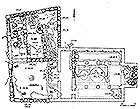
| Development Plan for the Site |
| Orderer | KKL-JNF |
| Duration | 2014-2011 |
| Implemented by: |
Arch. Yaara Shaltiel
Landscape Arch. Ido Rosental
|
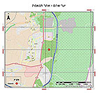
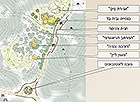
The Church of St. Bacchus is c. 300 m southwest of Horbat Tinshemet (Sheikh ‘Ali Malikina; Khirbet esh-Shamiya), which is currently situated within the jurisdiction of the city of Shoham (Fig. 1). As a result of the city’s rapid development, an archaeological park was planned in 1996-1997 in which the church and the adjacent complex of industrial installations will be displayed. Nine other archaeological sites are located in the area where the park is to be established.
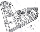
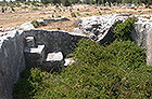
The site was discovered in 1986 when J. Porath uncovered part of the mosaic, at which time the area was declared an antiquities site. In 1995, Dr. Uzi Dahari directed a salvage excavation there on behalf of the Israel Antiquities Authority. Remains of a basilican church dedicated to St. Bacchus and an adjacent oil press were revealed in the excavation (Fig. 2). Twenty meters northeast of the church is a rock-cut pool that is surrounded by three plundered arcosolium tombs. Other antiquities that were uncovered include finds from the Byzantine and Early Islamic periods. Ancient stone quarries are also located in the vicinity of the church and oil press (Fig. 3).
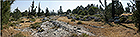
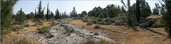 Fig. 3: A stepped rock-cutting north of the Church of the St. Bacchus.
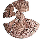
Researchers suggested Horbat Tinshemet, which is next to the church, be identified with Betomelgezis, which appears on the Madaba Map. The site is designated Khirbet Sheikh ‘Ali Malikina in the British Survey of Western Palestine from 1881. A marble medallion, 67 cm in diameter and 5.5 cm thick, bearing the image of the goddess Tyche was found during the excavations (Fig. 4). The researchers estimate this medallion was made in 582-3 CE. So far no parallel has been found for this artifact which is a unique find amongst the art of the Byzantine period.
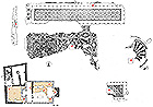
The church dates to the sixth century CE. It was built of large smooth ashlars hewn from soft limestone (nari). It measures 27 m long by 11.7 m wide. The church’s interior is square and consists of a nave and two aisles. The interior is divided by two rows of three columns. The nave is 4.75 m wide and each aisle is 2.2 m wide. The roof of the church was built of wooden trusses and roof tiles. A quarry and a lime kiln – both of which are ancient – were located alongside the church and were probably used in the construction of the complex. Over the years most of the good building stones were plundered from the site and all that remained were several rows of stones on the surface (Fig. 5).
The church’s mosaics were covered over in June 2002 so as to protect them until the site was developed, and an preliminary conservation survey of the remains of the Church of St. Bacchus was carried out in 2003. Over the years the covering on the mosaics was damaged mainly because of the flocks of sheep and goat that graze there, as a result of which weathering processes have developed that are detrimental to the mosaics (Fig. 6).
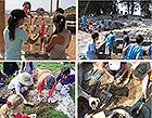
In 2011, a conservation project involving the design and development of the site was begun and an archaeological excavation was carried out that revealed previously covered parts. The main purpose of the project was to integrate the church in the leisure and tourism activities that are available nearby. The conservation measures were implemented in conjunction with the Jewish National Fund, and pupils from Shoham and the surrounding area participated in the work in order to create a connection between the community and the heritage in the vicinity of the settlement (Fig. 7).
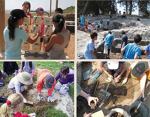 Fig. 7: Elementary school students maintaining the site as part of the "Adopt a Site" project.
The Cultural Significance of the Site
Historical value: The church, installations and tombs that were exposed represent a complex that reflects life in the sixth century CE.
Architectural and artistic value: The church is built in the form of a Roman basilica. The marble medallion bearing the image of the goddess Tyche is a unique find.
Landscape value: The church connects the burial and water storage complexes to an area of productive activity where there are wine presses and kilns (Fig. 8). Historic roads that linked Yafo, Lod, Jerusalem and Nablus passed nearby. Today, the Israel National Trail, which passes close to the site, gives the place new meaning.
Social value – cultural:
Wine culture – this is manifested by the wine presses that are hewn in the bedrock and the vine and wine jar decorations incorporated in the mosaics in the church. The church is named after the god Bacchus, which indicates the centrality of this motif in the lives of the residents.
Oil culture – remains of a beam oil press and two screws are located next to the church. The work of producing oil, like wine, was an inseparable part of the everyday life there during the Byzantine period.
Water storage – the streams in this particular geographic region are not perennial; hence the inhabitants needed cisterns to store water for agriculture and the other types of work that was carried out (Fig. 9).
Social value – religious: the church was the center of social and religious activities. Rock-hewn tombs dating to the same period were found next to the church (Fig. 10). This fact reinforces the status of the church as a both a social and religious institution.
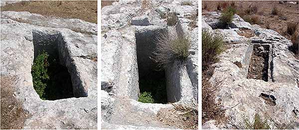 Fig. 10: Rock-hewn tombs.
Conservation Measures
In 2011, conservation work began at the site with the participation of the local population. The intervention included: cleaning and stabilizing the mosaics, stabilizing walls, cleaning pits and tombs, preparing a visitor’s path to the site, marking and fencing off pits and the reconstruction of walls for display purposes (Fig. 11).
Fig. 10: Rock-hewn tombs.
Conservation Measures
In 2011, conservation work began at the site with the participation of the local population. The intervention included: cleaning and stabilizing the mosaics, stabilizing walls, cleaning pits and tombs, preparing a visitor’s path to the site, marking and fencing off pits and the reconstruction of walls for display purposes (Fig. 11).
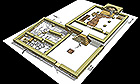
The intervention emphasized the public benefit value of the site, that is, by readying the site for visits by the public and creating study areas for learning about the Byzantine period (Fig. 12). The illustration of selected topics and their presentation was done by means of models that explain the finds at the site, among them: the church, oil press, wine presses, water reservoirs and tombs.
Additional Sources
Dahari U. 1996. Horbat Tinshemet: Church of St. Bacchus. Hadashot Arkheologiyot 106. (Hebrew).
Dahari U. 1996. Excavation and Surveys in Israel 18, 67-68, 102-104.
Dahari U. Khirbet Tinshemet: Church of St. Bacchus near Horbat Tinshemet. Israel Antiquities Authority internet website.
Guerin M. V. 1875. Description géographique, historique et archéologique de la Palestine, Sam II, 76.
Kochavi M. and Beit-Arieh I. 1997. Map of Rosh Ha-‘Ayin (78). Archaeological Survey of Israel. Israel Antiquities Authority.
To view the figures, click on the figure caption
|
|