The aim of the work at Gamla was to define the preliminary conservation measures needed to stabilize the remains at the site, and to evaluate the site’s cultural significance as a basis for an initial conservation program and out of a desire to enlist resources and contributions for the purpose of continuing archaeological research, completing the exposure of the site, and its conservation and development in preparation of opening it to the visiting public.
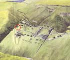
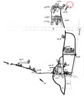
In 1997-2000 a large part of a magnificent public building, known as the ‘Basilica Structure’, was exposed in the western area of the settlement at Gamla, far from the city wall and the synagogue, in the upper section of the wealthy quarter being uncovered on that part of the slope (the western quarter – Square S). The attention of the researchers and excavators at the site was drawn to the high western corner of this quarter. There, in a strip c. 30 m wide, were numerous fine quality architectural elements, including neatly dressed ashlar stones, numerous bossed stones and a lintel stone decorated with a rosette and two palm trees. The similarity between the engraved rosette on this lintel stone and the carving on a fragment of a lintel that was found in the synagogue in the eastern part of the site suggests that another synagogue once stood here also.
The most striking and important aspect of the ‘Basilica Structure’ is its being a kind of Jewish public building that is new to archaeological and historical research. Its location in Gamla, alongside the remains of one of the earliest synagogues ever exposed in the country, raises renewed questions regarding the significance of the synagogue as an institution, its nature and function during the Second Temple period.
Danny Syon and Zvi Yabor, the researchers investigating the site and who have directed the excavation expedition at Gamla in recent years, propose identifying the ‘Basilica Structure’ with an early variant of the Talmudic court of law (Bet Din) which until today was considered to be one of the uses of the synagogue. Based on a quotation by Josephus Flavius pertaining to the appointment of judges in the cities of the Galilee: ” he chose out seventy of the most prudent men, and those elders in age, and appointed them to be rulers of all Galilee, as he chose seven judges in every city to hear the lesser quarrels…” (Jewish Wars II: 20:5), Syon and Yabor suggest that what we have here is the municipal court of law that served the community in Gamla.
The destruction of the building, like all of Gamla, occurred in the year 67 CE. From the time of its destruction until it was exposed in recent years the site was not reinhabited, and thus researchers and visitors alike can enjoy the unique experience of a Jewish city in general, and this specific building in particular, as they have survived from the time of the Second Temple.
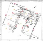
The ‘Basilica Structure’ extends across an area of c. 240 sq m: c. 15 m wide along an east west axis and c. 17 m long from north to south. The building consists of three main longitudinal wings and each was apparently covered with wooden beams. The walls (c. 1 m wide) are built of large dressed basalt stones arranged as header-stretchers. The core of the walls is composed of indigenous soil, small fieldstones and debris from the stone dressing. The joints between the masonry stones were filled with numerous stone fragments and mud bonding material. It should be noted that similar size masonry stones were only used at Gamla in the construction of the synagogue.
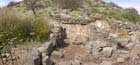
The eastern wing, c. 5 m wide, is divided into two rooms and treated with a fine white plaster, some remains of which can still be seen on the walls. Its floor is tamped earth and is plastered. Beneath the stone collapse were discovered numerous bossed stones and carbon fragments and soot that were the remains of a mighty conflagration.
The central wing is also divided in two by means of a single step that serves as a threshold to a bema that is paved with a thick layer of plaster. At the ends of the threshold step, in the east and west, is a pair of ashlar pillars engaged in the walls of the building, which still bear a few remains of fine white plaster. The two capitals of the pillars were discovered on the bema and are dressed in a similar manner as the stone dressing on the pillars’ bases. This space, which apparently faced south toward the entrance opening, was covered with wooden beams perpendicular to the rest of the roofing in the building which was arranged from north to south. The manner of roofing and the raised floor testify to the importance of this space, which probably fulfilled a function similar to that of the basilica apse.
Extending south of the bema is an elongated rectangular hall (4.5 m wide, c.11 m long) that probably served as a nave. A pair of pillars that were engaged in the walls of the hall was discovered in its southern part. Remains of stone pavement between the pillars may attest to the existence of another step.
The western wing, which is the widest of the three (c. 7 in width), was only partially excavated; however, at this point in time we believe it was divided into three rooms.
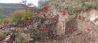
The ‘Basilica Structure’, like most of the buildings in Gamla, was not necessarily destroyed by the Roman conquest but by the natural collapse of the soil and rocks that slid down the precipitous slope, as evidenced by boulders that were found inside a number of buildings throughout the site. During the course of the excavation building remains were exposed that have survived prolonged destruction caused by landslides and rockfalls. The tall walls that were discovered without the support of their original ceiling and with their cores exposed to percolating run-off and repeated collapse were subjected to weathering and destructive processes, which was not the fate of the complete buildings. The danger of landslides and rockfalls still exists and threatens them again.
An attempt was made to partially stabilize the northern wall of the eastern wing.
The fundamental danger threatening the totality of the ruins is the lack of stability of the northern wall (W559) that functions as the retaining wall holding back the slope. In order to achieve a security strip to safely halt the rockfall, the slope has to be moved c. 1.5 m to the north and the run-off must be diverted to the east and west so as to prevent it from flowing onto the face of the wall. In order to stop the weathering and destructive processes caused by the exposure of the walls, preliminary conservation measures must be taken to protect the tops of the walls, their bases, the sides of the walls and their cores.
It is recommended that the entire building be completely exposed, including its western wing, in order to understand the plan of the structure and detect any other clues that may shed light on its purpose and function. Furthermore, it is recommended the excavation area be slightly expanded beyond the boundaries of the building in order to attempt to locate the approaches to the structure and determine its urban context.
During the stabilization and preliminary conservation measures to be undertaken the planners should generally avoid doing anything permanent in the area that will get in the way of future architectural and conservation planning and the presentation of the structure and its function.
The building is located far from the other focal points in the antiquities site and there is no proper path that connects it to the important remains there. How it links up with the visitors’ track will be addressed in light of the settlement’s urban contexts which will be determined only after the remains in the vicinity of the site are completely exposed. In the meantime we recommend that the location of the settlement’s western boundary be examined and how the building relates to it. In general, until the conservation and stabilization work are completed at the site the visitors’ path should not be prepared. As a matter of fact, the public should be prevented from visiting the Basilica Structure and its vicinity out of fear of mechanical damage due to inadvertent rockfalls. The building, like the remains of the entire site, is situated inside of a unique and rare nature preserve, the location of which enhances the value of the visitors experience at the site.
In the meantime, the ramifications of the excavation and conservation work should be carefully examined with regard to the removal of soil, debris and building materials so as to ensure they do not have a detrimental impact on the site’s environmental values, the vistas that can be seen from it and the appearance of the site from afar.