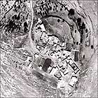
A survey of the cultural landscape at Kadita serves as a test case for the Delta Project.
Delta Project sought to create a model of a regional cultural system in which it is possible to conserve, develop and enhance the cultural resources by a combination of material and spiritual culture, infrastructure, services and productive sectors (Figure 1).
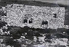
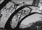
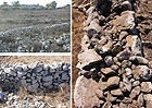
Remains of Kadita village are located on Har Kotar, near Safed. The village houses, which were built of basalt, were damaged in the earthquake of 1837; however, the village continued to exist until it was abandoned during the War of Independence in 1948 (Figure 2). The deserted houses in the village were demolished in 1966 in accordance with a government decision. The remains of the historic village include a cemetery and approximately ten cisterns. Although the latter are indicative of an ancient settlement no archaeological excavation has been conducted there. From a technological standpoint the construction is typical of the region, consisting mainly of coarsely dressed fieldstones and stone arches. The roofs of the buildings were made of organic material (Figures 3, 4).
The slopes of Har Kotar are part of the Nahal ʽAmud drainage basin. In 1972 the stream was declared a nature preserve that also includes the Kadita terraces. In 1988 the Israel Lands Administration allowed four families to settle among the farming terraces there. The Israel Lands Administration is promoting a plan to establish an ecological community of 150 families there.
Traditional Farming in Kadita
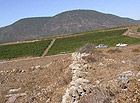
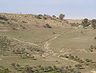
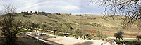
The Kadita region is characterized by farming terraces that were cultivated by the villagers. The region was used for grazing in the second half of the twentieth century. The terraces are built in a stepped manner which allowed efficient utilization of rainwater such that the excess water and alluvium drained from the upper terraces to those below them.
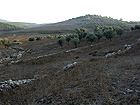
At the top of the mountain, where the slopes are moderate, the plots are often delimited by stone walls 0.6-1.5 meters high. These are broad plots and were presumably used for growing unirrigated crops (Figure 5). On the other hand, the terraces on the steep slopes are stepped and are characterized by a slight incline. They were built of dry construction utilizing small and large stones, and for the most part fruit trees were planted on them (Figures 6, 7). Excess water was conveyed in conduits to the Nahal ʽAmud river channel (Figure 8).
The terraces illustrate a simple means for maximum utilization of rainwater for growing unirrigated crops that is typical of the mountainous region. Cultural values are also found in the watchman’s huts. These are indicative of the lifestyles in the mountain regions of the Mediterranean basin.
Although the survey focused on the array of farming terraces and water channels in Kadita, they should be regarded as part of a regional system that continues with the mills located in Nahal ʽAmud. This system presents a variety of technologies for exploiting water power for agriculture and traditional forms of work in the Upper Galilee.
The survey recommends conserving the cultural landscape of Kadita, that is, the system of farming terraces. A successful example of this exists at Sataf in the vicinity of Jerusalem. It is also recommended that the conservation processes and the use of the terraces for cultivation be done by the local community, with the assistance of relevant professionals.
In conclusion, the traditional agriculture on the farming terraces, which was common in the Upper Galilee, and the cultural landscape components at Kadita, which developed over the course of centuries and millennia, are now threatened due to accelerated development trends (Figures 9, 10).
The conservation of this cultural landscape has high tourism potential owing to the landscape values of the region and Kadita and due to the proximity of the village to existing tourist attractions.