Historical-Archaeological Overview
The Bronze Age. The level of the sea was c. 15 meters higher than its present level (Zvieli 2006). The stream served as a transportation artery between the tells and the sea.
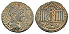
In the Hellenistic period ʽAkko expanded westward toward the peninsula. At the time the Na’aman was called Belus. Coins from the period indicate a cult honoring the god of the river, and festive processions along the stream (Fig. 2). It was during this period that the manufacture of glass was developed in the Na’aman estuary where the sand is rich in minerals and provided excellent quality raw material.
In the Roman period a harbor was established in ʽAkko and glass production in the Na’aman estuary flourished. This work is described in both the writings of Josephus and those of the Roman historian Pliny the Elder.
In the Crusader period the region served as the agricultural hinterland of ʽAkko, which became the capital of the Kingdom of Jerusalem. Flour and sugar mills were built along the stream and the sugar industry prospered. During this period the stream was used as a transportation artery.
Two buildings dating to this period have survived: the Doq flour mill of the Templar Order and the Recordane flour mill of the Hospitaller Order.These mills were at the heart of a dispute between the orders which was primarily a struggle for control of the source of the Na’aman, management of the water regimen and navigation rights on the stream.Crusader remains were identified at Ridvan Mill (see below).It has been suggested that “the King’s Mills”, which are known from historical documents and were used in the manufacture of sugar, were located there.
In the Ottoman period Ridvan Mill was built, which is one of the largest in the country.However, the mill dams and flawed maintenance of the channel turned the Nahal Na’aman basin into a swamp.
The flour mills appear on the Jacotin Map of 1799, the time of Napoleon’s siege of ʽAkko. Some of them were rehabilitated then for the purpose of providing food for the soldiers.
The British Mandate. The mills were purchased at the end of the 1920s by the Palestine Land Development Company. The company worked to drain the marshes, eradicate malaria and create land for agriculture and construction. The water from the Na’aman was routed to a straight artificial channel that is several kilometers shorter than the stream’s original route. The channel was diverted west; the original course dried out and was turned into farmland.
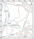
Sites in the Vicinity of the Stream
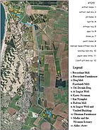
The sites are tangible evidence of the cultures that existed in the vicinity of Nahal Na’aman:(Fig. 3)
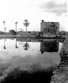
Recordane Mill. The mill is currently located within the precincts of the ʽEn Afek Nature Reserve. The Hospitaller Order built it in about the mid-twelfth century and it was operated by water power from the ʽEn Afek springs.The mill remains – a pentagonal foundation and a stone chute – were exposed during the course of development work in the region. The mill is presently flooded and covered with dense vegetation.
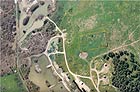
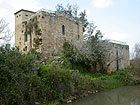
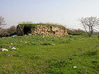
Recordane Farmhouse. Remains of the base of a farmhouse that dates to the Crusader period are located at the top of Tel Afek. Over the years the building was dismantled and its stones were taken for building material at different construction sites throughout the region (Fig. 4).
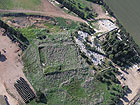
Doq Mill. (Kurdaneh Mill).The mill is currently located within the precincts of the ʽEn Afek Nature Reserve.This is a fortified mill with a chute and dates to the late twelfth century.The original structure has been modified and pairs of millstones were added to it.Today there are five pairs of millstones in the building.The mill components also include a dam 625 meters long that conveyed the water to the mill chutes.The dam created a lake 2.7 meters high before the mill.In the nineteenth century and early twentieth century the mill and the land around it were owned by the Sursuq family of Lebanon. Three workers operated the mill and it served the settlements in the Zebulon Valley, the residents of the Western Galilee and Shafarʽam. In 1925 the Jewish National Fund purchased the installation (Figs. 5, 6).
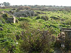
Tel Da'okh/Doq. Remains of a barrel-vaulted Crusader farmhouse built around a central courtyard. A saqiye well is located next alongside it. The structure was also used during the Mamluk and Ottoman periods. The tell is today located near Kefar Masaryk. (Fig. 7)
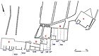
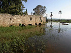
Ridvan Mill. A complex of flour mills powered by water from the Na’aman that was diverted from its original channel in the lowest water head known in the country and utilizing traditional horizontal paddlewheel technology. Instead of the chute, which was customary in the coastal plain mills, horizontal sluices were used.
The complex of flour mills, including the sluices, vaults and buildings, is unique in the country due to its size and the state of its preservation. There are fifteen pairs of millstones in five buildings, which were apparently operated simultaneously. The relative integrity of the southern façade, which extends an overall length in excess of 75 meters, reflects the industrial strength of the complex (Figs. 8, 9).
With the diversion of the Na’aman and the draining of the marshes, the stream’s water no longer reached the mills. The northern channel, called the “Prisoners Sluice” was filled-in in order to prevent the prisoners in ʽAkko prison from becoming ill with malaria.
A Saqiye Well and Vaulted Building. The well is located southeast of the Ridvan Mills. Of the thirty wells that were situated in the region the remains of very few have survived about ground level (Fig. 10).
Ottoman Farmhouse. In 2001 Dothan Druck of the University of Haifa excavated the remains of the building. The site includes a residential building and a shallow well in which a saqiye was installed. The water was conveyed through a series of aqueducts to the farmhouse and the cultivation plots (Fig. 11).
Karei-Na'aman. The Karei-Na’aman Nature Reserve presents the Na’aman landscape as it existed before the stream was diverted to the channel and the marshes were drained.
Ein Nymphit. A nature reserve covering an area of c. 62 dunams, preserving remains of the Na’aman marshes. It was established as a nature reserve in 1968.
Malha and the Na’aman Estuary. Remains of glass kilns scattered along the coast.
In conclusion, the stream’s channel between Afek and ʽAkko and its landscape are a product of human intervention. Remains dating to the Crusader period are present the length of the stream. They are also attested to by historical documents that confirm the finds. The eastern bank of the stream presents a landscape of farming culture that characterized the Zebulon Valley throughout history. Unlike the streams of the Western Galilee, where the topography is precipitous, the gradient of Nahal Na’aman is moderate and the amount of water is great. This fact essentially dictated the use of water-powered installations with chutes and made it possible to exploit the stream as a transportation artery.
The master plan, with minor changes, can reflect man and nature’s relationship the length of the stream, and offer the visitor a diverse experience along it.