| Tel Jezreel |
| Tel Jezreel |
| A Conservation and Development Program |
| Orderer | The Southern Jordan Drainage Authority |
| Duration | June - October 2009 |
| Implemented by: |
Arch. Lilach Strul
|
Tel Jezreel is located southeast of Afula, near Kibbutz Yizre’el. The tell and the kibbutz are just to the north of the “Ta’anachim” road (Highway 675) that connects Highway 65 with the Bet Sheʽan-Afula road (Highway 71). The tell rises to an elevation of c. 100 meters above sea level and extends across an area of c. 60 dunams.
The tell is located at the northern end of Israel’s central mountain range (Hebron-Jerusalem-Shechem-Megiddo) which terminates at the Gilboa Mountain ridge. The northern slopes of the ridge drop precipitously toward the chain of valleys that cross the country widthwise (Bet She’an-Harod-Yizre’el-Qishon). The tell is situated at the top of a hill, on a mountainous spur that that stretches from the Gilboa Mountain ridge to the northeast.
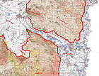
The spur encroaches into the Jezreel Valley, has a commanding view of the valley and splits it in two (Fig. 1).
The geographic conditions have rendered the tell tremendous strategic importance since it looks out over the region in four directions, overlooks the country’s fertile valleys and controls the road that runs through the chain of valleys.
The aim of the present work was to create a program for future development that will prepare the tell for when it is opened to the public.
Historical - Archaeological Description
In 1987 Pinchas Porat and Ora Yogev conducted an excavation on Tel Jezreel, on behalf of the Department of Antiquities and Museums.
David Ussishkin, Ram Gophna and Zvika Tsuk conducted excavations on the tell in 1996-1998, on behalf of the Institute of Archaeology of Tel Aviv University.
In 1991 Aaron Meier headed an excavation to Tel Jezreel, on behalf of the Institute of Archaeology of the Hebrew University of Jerusalem.
John Woodhead carried out excavations there in 1991-1996, on behalf of the Council for British Research in the Levant.
In 2007 Howard Smithline of the Israel Antiquities Authority excavated on the tell, as did Tvika Tsuk of the Institute of Archaeology of Tel Aviv University.
Based on the information that has been gathered to date, no conservation measures have been implemented to the finds on the tell, apart from the agricultural installations located on the eastern part of the mound.
Tel Jezreel was inhabited from the Neolithic period until the establishment of the State of Israel. The only finds that exist from the Neolithic period and the Bronze Age are pottery sherds. Archaeologists believe there was a village in the center of the tell but all traces of it were eradicated by the construction that occurred there in subsequent periods.
The finds that survived from the Iron Age include remains of a monarchic fortified compound dating to the Omride Dynasty.
The building remains of the Persian, Hellenistic and Roman periods that were exposed do not form a clear layout of a settlement.
There was a large village on the mound during the Byzantine period and it continued to exist in the Crusader period as well.
In the Ottoman period the village, which was called Zarʽin, was large and existed there until the end of the 1940’s.
The archaeological excavations focused mainly on locating the building remains from the Iron Age and identifying them with the palace of King Ahab in the biblical story about Naboth’s vineyard.
The Finds
The importance of the tell stems from the positive identification of the monarchic compound from the Iron Age and its connection with a biblical event.
The monarchic compound of the Iron Age occupies the entire top of the mound and is rectangular and fortified. The perimeter fortifications are composed of a moat, a lower wall, a rampart and a casemate wall (from the outside in). Towers were incorporated in the corners of the fortifications. The compound’s gate is integrated in the southern side of the fortifications, slightly east of the center. It is believed that this gate was the only entrance to the complex.
On the edge of the mound are the remains of a Crusader church that was probably built on those of a Byzantine church.
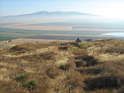
The remains of a large Ottoman building (Fig. 2) are located on the western part of the top of the mound.
Problems that have been Identified at the Site
The tell and its finds are subject to natural processes of deterioration that occur when there is no human activity there. These are characterized by the disintegration of the remains and the rampant growth of vegetation.
Vegetation, which covers the tell and obscures the excavation squares and the archaeological remains, hastens the deterioration processes.
The balks in the excavation squares are not stable. The fences, which were erected in the past at the tops of the excavation squares in order to ensure the safety of visitors to the site, are falling apart and are disappearing.
The building materials are visibly deteriorating: the mortar has disintegrated thereby speeding up the process whereby the walls fall apart.
The archaeological remains are unstable and are insufficiently clear and incomprehensible to anyone looking at them.
In its present condition, it is dangerous for anyone to walk around the mound. The hazard stems from three main factors:
• Difficulty in identifying the excavation squares and their unstable balks.
• The multitude of cistern openings that are obscured by vegetation and are not closed with gratings.
• Unstable walls (Fig. 3).
The Development Program
Two basic alternatives were examined:
1. Develop the tell and prepare its surroundings for the public. The development will be based on an interpretation of the Israelite monarchic compound and will illustrate it; content and stories that are related to the place will be presented.
2. “Mend” the surface of the “damaged” landscape where the excavation squares are located. According to this approach, the tell will be treated as a landscape component, the surface of which has been damaged. The treatment will result in mending the surface of the landscape and will present the mound as a natural region, without intervention, without any preparations for opening it to the public, without development and without a proper visitor’s path.
This alternative calls for improving the conditions in the woods located on the east of the tell in order to receive more visitors. The existing walking path leading to Ein Yizre’el will remain unchanged but the possibility of upgrading it will be examined.
Both intervention alternatives will respect the natural aspects of the place and this shall be done out of sensitivity to the landscape, by reducing the resources and by reducing the environmental impact. In order to achieve these objectives a detailed interface program is required.
The Measures Required to Prepare the Tell and its Environs for the Public
- Draw up an interface plan. A detailed conservation plan for the tell and its development as seen from a regional perspective.
- The system of paths and roads that access the tell needs to be changed. The parking facilities in the southwestern part of the tell will be adapted for the handicapped and vacationers in the woods. The existing access road will be completed as far as the Gilboa Junction and will become one way.
- Minimum measures will be taken to upgrade the existing walking tracks between Tel Jezreel and the Gilboa Junction, Kibbutz Yizre’el and Ein Yizre’el.
- Due to the poor preservation and unstable physical state of the archaeological remains, the development of the tell will not be based on a presentation of the tangible artifacts but rather on presenting content and events that are related to it.
- Most of the archaeological remains will be covered over after they are stabilized. Some of the finds will be prepared for presentation or will be integrated into the architectural intervention.
- The main points of interest will be the remains of the monarchic compound that dates to the Iron Age, the presentations that will be installed to clarify it and the vantage points that look out over the landscape.
- Other points of interest are: archaeological remains from later periods, caves, cisterns and agricultural installations. In addition to these there is a grove, a monument to the Palmach, environmental sculpture and a small cemetery that was established after the founding of the State of Israel.
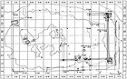
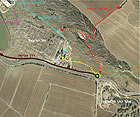
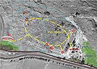
- A circular track has been proposed for the top of the tell between the points of interest and it will be handicap accessible. The track will be connected to two parking lots: one in southeast of the tell and the other in the southwest of the tell (Fig. 5). Secondary paths will connect the circular track to other points of interest, to existing paths and hiking paths (Fig. 4).
The archaeological remains will not be restored or completed; instead the aim of the program is to stabilize them from an engineering standpoint.
Architectural intervention will be permitted in order to create observation points, where there will be both explanations and illustrations, which lookout over the landscape.
Bibliography
D. Ussishkin and J. Woodhead 1994. Excavations at Tel Jezreel 1992-1993: Second Preliminary
Report. Levant Volume XXVI, pp. 1-48.
...........................
Lilach Strul, June 2010
To view the figures, click on the figure caption
|
|