| Nahal ‘Amud |
| The Flour Mills |
| Documentation and Survey |
| Orderer | The Antiquities Authority, Delta Project |
| Duration | April 2004 – June 2006 |
| Address | Nahal ‘Amud Nature Reserve |
| Implemented by: |
Arch. Amir Freundlich
Arch. Yaara Shaltiel
|
The documentation and survey were conducted within the framework of the Delta Project. Their purpose was to create an up-to-date data base for planning the conservation and development of the flour mills along the river, while carefully maintaining a balance in the integration of the antiquities with the rich flora and fauna in the reserve. The work consisted of mapping all of the remains of the installations within the area of the reserve and documentation included photographic and measurement.
Nahal ‘Amud is a perennial stream. The source of the river is located on the Dalton Plateau to the north; it flows west of the city of Safed and its outlet lies on the northwestern shore of the Sea of Galilee. The entire length of the river is a declared nature reserve containing diverse landscapes, springs, and a wealth of fauna and flora. The upper part of the reserve, between Nahal Meron in the north and Nahal Shamai in the south, draws numerous visitors throughout the year, particularly during the summer months when the rich vegetation provides shade from the burning sun, the flowing water cools the air and the orchards are ripe with fruit.
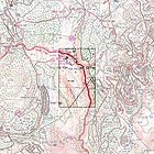
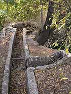
From the time of the Crusader period until the creation of the State of Israel the upper part of the river has been an agricultural area that also included the flour and cotton industry for the city of Safed, which was an urban center for the surrounding agricultural settlements. Remains of terraces, flour mills, water channels and bridges can be seen through the maze of vegetation growing along the river and they are silent evidence of this region’s past and of the ancient technology that is quickly disappearing from the landscape. Eighteen flour mills, ten bridges and five diverting dams were identified in this section of the river, which is about 2.5 kilometers long. Such a density of installations is rare in the Land of Israel and unique to it.
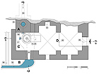
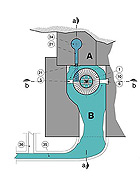
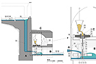
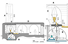
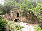
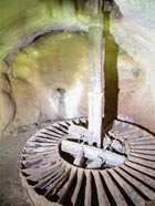
The flour mills in Nahal ‘Amud are ‘chimney’- like tower mills in which the water power was exploited by means of raising a water column inside of a ‘chimney’ that was built to a height of 6.0-9.5 m, in accordance with the topography. A concave cell containing a paddlewheel was built at the base of the ‘chimney’ and above it was a milling room containing the millstones. In most instances vaulted halls and space for storing the grain and the flour, as well as a place for the millers to stay, were built next to the milling room. The average area of a mill is c. 50 sq. m.
We know from historical sources that during the golden age of Safed, in the 16th century CE, there were fulling mills in Nahal ‘Amud where wool textiles were cleaned by water power exploited in a similar fashion as in the flour mills. We are quite certain that the flour mills that are currently visible in the river channel were erected atop the remains of the fullings mills. The previous use of one of the flour mills is preserved in its Arabic name – ‘Takhounat al-Batan’ (‘batán in Spanish means fulling mill).
The State of Preservation of the Mills. In some of the mills only the remains of the foundations have survived whereas in others there are complete buildings and installations that are still in situ. Most of the remains of the flour mills have been subjected to weathering processes and varying degrees of damage; some are in imminent danger of collapse. Several years ago part of Mill M9 (the fulling mill) collapsed and in the wake of that event the Nature Reserve and National Parks Authority restored the building’s facade.
During the survey and documentation work guidelines were formulated for stabilizing the mills that are in immediate danger of collapse. This was done in coordination and partnership with the Nature Reserve and National Parks Authority; however, the stabilization work has not yet been implemented.
Further Study. The extremely dense vegetation along the river channel conceals many mill remains and the installations associated with them. Landslides and rockfalls caused by erosion and the movement of wild boar have covered some of the remains and even prevent access to several of them. These conditions made it difficult to carry out the documentation and surveying work and restricted it. The completion of gathering information and the study of how the flour and fulling mills worked in the past are predicated upon first uncovering the remains hidden beneath the vegetation, alluvium and collapse.
Stabilization and the Removal of Hazards. Some of the mill remains are in imminent danger of collapse and constitute a significant safety hazard to both the visitors to the site and to the completeness of the adjacent remains. In order to eliminate this real danger and preserve the remains in their current state for future generations, it is necessary to implement measures that will stabilize the remains in ten of the eighteen mills along the river (M4, M7, M10, M11, M12, M13, M14, M15, M16, M18).
Development and Presentation. The flowing water is the common thread that connects the different kinds of built remains to each other, to the river and to the nature reserve. In order to present the traditional technology and to intensify the visitor’s experience in the reserve we recommend that measures be taken to allow the water to flow through the installations.
Based on an analysis of the state of preservation of the mills and water conduits and the focal points of interest and where the public will visit in the river, we recommended that the presentation and illustration be concentrated between Mills M10-M13, beginning from the diverting dam above Fulling Mill 9 and ending with Mill M13 south of the grouse pools, and to permit water to flow in them as described in the diagram of the array of mills we propose for presentation.
Acknowledgements. The documentation and survey work in the nature reserve and on the precipitous slopes of the river was made possible thanks to the cooperation provided by the staff of the national park, headed by Eliezer (Lazar) Bergman, who assisted us in the work of exposing the remains, pruning the vegetation and arranging approaches to the sites and for which we are most appreciative.
To view the figures, click on the figure caption
|
|