| Jerusalem |
| Zedekiah’s Cave |
| Donor File, Site Development Program |
| Orderer | Western Wall Heritage Foundation |
| Duration | April, 2008 |
| Address | Sultan Suleiman Street |
| Implemented by: |
Arch. Marcus Edelcopp
|
This donor file was compiled in order to raise funds for the development of the site.
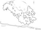
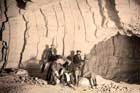
Zedekiah’s cave is the largest man-made cave in Israel; it is 230 m long and covers an area of 9,000 sq m. It extends below the Moslem Quarter of the Old City, as far as the Via Dolorosa. The entrance to the cave is located on Sultan Suleiman Street, c. 120 m east of the Damascus Gate. A paved plaza and trapezoidal shaped staircase lead to a small opening with an iron door through which one enters into a large cave, to its galleries and a myriad of tales.
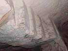
Zedekiah’s Cave was originally used for quarrying building stones in different periods. Squares, rectangles, grooves and rock masses in the walls of the cave, the ceiling and the floor are all evidence of the quarrying activity that occurred there.
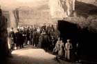
Several stone cutting methods that are attributed to the First Temple period have been identified in the cave, but it is the quarrying methods that are characteristic of the Second Temple period that are particularly prominent. Despite this, scholars do not define the periods during which the cave was used as a quarry. The cave was certainly used as such in the Second Temple period. King Herod apparently utilized the stones that were removed from the cave in the construction of the Temple and probably also in building the enormous walls that enclose the Temple Mount, including the Western Wall. We do not know if the cave was used as a quarry in later periods. There are scholars who believe the cave was sealed in the eleventh century by the Fatimids who feared their enemies would use the cave in order to break their way into the city. In any event, the cave was closed until the middle of the nineteenth century. In 1854 the American minister James Turner Barclay accidentally discovered the opening to the cave and he also surveyed it. The last time that stones are known to have been quarried in the cave is associated with the construction of the clock tower above Jaffa Gate at the beginning of the twentieth century.
The cave has many names:
Zedekiah’s Cave. This is the best known name of the cave. Legend has it that in 586 BCE while fleeing toward Jericho King Zedekiah hid in the cave.
King Solomon’s Quarries. From the moment that scholars realized that this cave was formed or was enlarged as a result of quarrying activity they began wondering who the first miners were that used it for building Jerusalem. The Bible states,
“And Solomon had three score and ten thousand that bore burdens, and four score thousand that were hewers in the mountains; besides Solomon's chief officers that were over the work, three thousand and three hundred, who bore rule over the people that wrought in the work. And the king commanded, and they quarried great stones, costly stones, to lay the foundation of the house with hewn stone. And Solomon’s builders and Hiram’s builders and the Gebalites did fashion them, and prepared the timber and the stones to build the house” (I Kings 5:29-32).
These verses have led various researchers to assume that Solomon used this cave for quarrying the building stones to construct the Temple Mount. Hence the cave was given the name it is still known by today: King Solomon’s Quarries. It should be mentioned in this regard that Charles Warren, who arrived in Jerusalem at the head of the Palestine Exploration Fund expedition in 1867, was a member of the Free Masons who considered King Solomon to be the order’s patron.
The Royal Caves. In a letter sent by the director of the Mandatory Department of Antiquities to the head secretary of British government on February 27, 1946, he refers to the cave and its names. He writes that “(King) Solomon’s Quarries are the same place which is also called the “Caverns of the Kings” that were mentioned by Josephus in his description of the Third Wall in Jerusalem (Wars of the Jews 5.4.2)
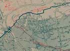
The Cotton Cave. Other names of the cave are mentioned in the same letter: “the caves are also mentioned by Mujir al-Din in the fifteenth century when they were called “Migharat al-Kitan” (caves/voids for linen/cotton) and were described as such by a Turkish traveler again in the sixteenth century”. The name Cotton Cave appears on various maps such as one of Jerusalem from 1873 that was prepared by R. Claude Conder, one of the pioneers of archaeological research in the Levant. The name “Cotton Grotto” appears on the map close to the entrance to the cave. On another map that was prepared ten years later by Hermann Guthe, a famous German Semitist, is the name “Eingang zur Baumwollengrotte” (the Cotton Cave).
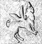
The carved “cherub” is another element that is connected to the legends of the cave. In 1874 the French archaeologist Charles Clermont-Ganneau discovered an etching in the rock in the eastern part of the cave, which depicts an image that has the head of a man and the body of a winged-lion. The scholar extracted the carving from the rock and it is today in London where it is kept by the Palestine Exploration Fund.
The Site’s Values
The historic value of Zedekiah’s Cave stems from it being Jerusalem’s principal quarry for building stones for at least 2,000 years. Furthermore, there are technological values that are hidden inside the cave thanks to the quarrying marks that are there, which are indicative of the work methods used by the quarrymen.
Evaluation of the Physical Condition
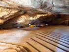
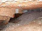
The cave’s level of preservation is good and there are no apparent engineering problems. The cave is open to the public daily. The cave’s state of preservation does not require any conservation action.
Principles for Intervening at the Site
The principles of developing the site, which are proposed in the donor file, are adapted for implementation in a cultural heritage site. Emphasis will be placed on reversible intervention that does not cause physical damage to the heritage or promote damage to the site. Accordingly, it was proposed that a walking path made of wooden treads be prepared that will be laid down on the existing soil; a railing will be designed along the visitor’s route in the cave and a storage area will be prepared for events that will take place in the “Free Masons” hall. The cave will be handicap accessible.
Entrance to the Cave. The entrance to the cave will be indicated by means of signage and explanations. The entrance gate, information counter and ticket sales point will be designed in the spirit of the place and an inclined ramp will be constructed to allow access to the handicapped.
Signage. It is recommended that signs be posted at the entrance of the cave for the purpose of explaining the site. These will include a description of the history of the place and a map of the cave that will be displayed against a background of a map of the Old City. Furthermore, explanatory signage will be posted in a number of places inside the cave.
Lighting. Lighting will be installed along the walking path, in the galleries and at a number of points of interest such as where there are quarrying remains in the bedrock or the location of the “carved cherub”.
Conclusion.
The donor file presents possibilities for tourism development at the site, in accordance with intervention principles at heritage sites. When the required resources have been raised for the tourism development in and around the cave, detailed planning of the proposed building specifications will be needed.
Sources
Bahat D. 1980. Carta Atlas of the History of Jerusalem. Jerusalem.
Friedman Thomas L. 1985. “Quarrying History in Jerusalem”. New York Times, 1 December
1985.
Sasson A. 2002. Zedekiah’s Cave – Evidence of Traditional Quarrying Methods in the Land of
Israel. In Y. Eshel (ed.), Studies of Judea and Samaria 11. Ariel. Pp. 345-358 (Hebrew).
State of Israel Archives
Ancient Maps of Jerusalem. The Eran Laor Cartographic Collection - The Jewish National and University Library & the Hebrew University of Jerusalem. http://maps-of-jerusalem.huji.ac.il
--------------------------------------------
Marcus Adelkop, Mars 2009
To view the figures, click on the figure caption
|
|