|
| Tel Yarmuth |
| Survey and Preliminary Program |
| Orderer | The French Institute |
| Duration | May 2005 |
| Implemented by: |
Reuven Elberger
Arch. Yaara Shaltiel
Yoram Sa'ad
Tamar Peretz
|
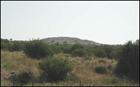
Tel Yarmuth is located 25 kilometers southwest of Jerusalem and 5 kilometers south of Bet Shemesh, between Tel Bet Shemesh and the Tel Azakah National Park. Nahal Yarmuth runs along the northern foot of the tell.
In this project a preliminary program was conducted entailing the conservation and development of Tel Yarmuth, so as to prevent further destruction of the site, and the preservation and display of its remains to the public.
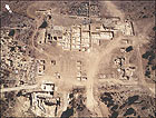
The excavations uncovered the remains of the biblical city of Yarmuth that date to the Early Bronze Age, including an impressive system of fortifications, a large palace, residential quarters and public buildings, as well as a small acropolis overlooking the city in which there also existed a settlement in later periods. The city was completely abandoned and therefore the finds from the Early Bronze Age were not disturbed in later periods.
The Identification of the Site
Tel Yarmuth (Khirbet el-Yarmut) is situated in the central Shephelah. Yarmuth is first mentioned in the biblical description of Joshua’s conquest of the country (Joshua 10:3-5) and later as a city in Judah (Joshua 35:35, Nehemiah 11:29). Owing to the few pottery sherds from the Late Bronze Age and Iron Age at the site, and in light of the fact that the archaeological strata from these periods have not yet been discovered, the archaeological evidence is insufficient to either contradict or corroborate its identification. The site can definitely be identified with the Byzantine village ΊЄρμοхώς (Yarmas).
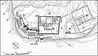
The Excavations at the Tell
To date approximately twenty seasons of excavations have been conducted at Tel Yarmuth. The first took place in 1970, on behalf of the Hebrew University of Jerusalem, under the direction of Professor Amnon Ben-Tor. Since 1980 the renewed excavations at the site have been conducted by the French Centre National de la Recherche Scientifique and the Institute of Archaeology of the Hebrew University, under the direction of Professor Pierre de Miroschedji.
The finds at the site are c. 4 m deep and include the following strata:
Early Bronze Age 1 – a thin stratum on the surface of the bedrock.
Early Bronze Age 2 – a stratum c. 2 m thick.
Early Bronze Age 3A-B – represented in five architectural phases.
Beginning of the Byzantine period – the remains of a number of buildings were discovered in this stratum, as well as pottery sherds scattered across the surface level.
Tel Yarmuth is primarily ascribed to the end of the fourth millennium BCE (EB 1) and most of the artifacts that were discovered there are attributed to the Early Bronze Age 2-3, an era in which the cities of Canaan and the Levant developed in general. The settlement in this period was developed, fortified and well-planned. Among the remains that one can identify are a cyclopean wall, massive fortifications, a magnificent palace and a temple. This is the period when the tell changed from a rural settlement to an important city-state that controlled the Shephelah. The size of the tell, its might, scope and the impressive finds that were discovered in it leave no doubt we are dealing with one of the most important key sites in the Bronze Age.
The Principal Finds
The excavations uncovered a magnificent system of fortifications of unparalleled scope around the site. The fortifications include a city wall that was constructed in phases and a series of platforms that together reach a width of 38.5 m and an entrance gate defended by a bastion. An impressive palace was also discovered that is 6,000 sq m in area and enclosed by walls that are meticulously built with perfect angles. The eastern part of the palace served as the official and public center and in the middle part there were storehouses, some of which were paved. It is apparent that part of the palace comprised a second story as alluded to by the remains of stairs. The palace functioned for a period of only one hundred years until it was conquered and no longer used.
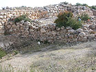
The remains at the site are impressive both in their scope and in the level of preservation representing the building technology of the period. The fortification system consists of several phases: first, a stone wall 5.6 m thick preserved to a height in excess of 4 m that dates to the third millennium BCE. The wall was later reinforced by glaçis-like stone supports in front of which was built a terraced slope 30 m wide. A second line of fortifications was built along the end of the slope at the end of the Early Bronze Age 2, when a cyclopean retaining wall was erected to a height of one to two meters, and the area between the walls was filled with small stone terraces with interior partition walls that were covered with plastered floors.
The roofs of the exhibited rooms in the palace and other public buildings at the site were supported by interior wooden columns that were positioned on stone bases that have survived at the site. A large colonnaded hall (c. 180 sq m in area) in which nine columns once stood will also be covered utilizing this method. Plaster remains, crushed chalk pavement and stone pavement were found in some of the buildings.
The finds are evidence of the developed building culture in the Bronze Age.
The Site’s State of Preservation
1. Damage and Weathering – the site was excavated over the course of many years without any accompanying conservation; the building remains that were revealed have not been treated to this day. The absence of conservation measures and on-going maintenance of the exposed remains at the site are leading to accelerated weathering which will ultimately result in the loss of the finds. The weathering of the finds is apparent in the crumbling of the construction materials – stone and bonding materials: the crumbling of the remains of plaster and pavement, the lack of bonding material between the stones, the formation of voids in the cores of walls, the tops of walls whose stability has been undermined, the collapse of masonry stones and vegetation taking root in the joints between the stones and in the wall cores.
Besides the natural factors for weathering there exist other factors as well, among them the exposure of the wall foundations at the site and the absence of drainage from the excavation area. Another problem is apparent in the excavation’s sectional trenches that are collapsing as a result of run-off undermining their sides at the bottom of the trench. In their current state the remains at the site are exceptionally susceptible to mechanical damage.
2. Vandalism – the fence at the site has been breached time and again by holidaymakers traversing the site in their sport utility vehicles. Having said that it does not appear that wanton damage has been caused to the remains.
3. Safety – there are open excavation pits and numerous sectional trenches at the site. Some of them are covered by seasonal vegetation and are therefore not readily apparent. The lack of warning signs and the removal of overgrown vegetation present a clear safety hazard for visitors.
In the tell’s current state without the conservation and stabilization of its ruins, when numerous excavation pits in the area are wide-open and others are hidden by seasonal vegetation, both the ruins and the visitors to the site are in danger. We therefore propose completing a detailed plan and to implement the conservation, stabilization and development work in several phases:
Phase 1. To immediately limit access to the site.
Phase 2. Conservation of the gate regions (Area E). In the exposed gate there are walls c. 4 m tall that have not undergone any conservation measures to stabilize them and present a danger to both the finds and visitors to the site.
Phase 3. Conservation of the palace. The conservation in the palace will underscore its size, its distinct plan and the wings that were used to fulfill a variety of functions: the large courtyard, large hospitality halls and a wing that functioned as a storehouse and probably rose to a height of two stories. The conservation of the palace’s remains will be implemented in two stages: stabilization of the remains that have been exposed so far, and in the future – exposure and restoration for the sake of illustration and display.
Phase 4. Preparing a visitor’s track, development and illustration.
Phase 5. Completing the conservation and/or covering the excavation pits that are not part of the exhibit.
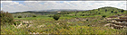
The uniqueness of Tel Yarmuth lies in the fact that it is an example of a complete settlement from the Early Bronze Age that was completely abandoned and, for all intents and purposes, was not inhabited again. The remains represent building technology that includes stone construction utilizing a variety of sizes and stone dressing methods, a few mudbrick building remains and the remains of finishing materials such as pavements and plaster. Rising above the excavated city is an acropolis offering a lovely view of the region. Other look-outs in the direction of Nahal Yarmuth and Nahal Ella can be seen from the tell itself.
The location of the tell in a nature preserve on the one hand, and at the end of an urban development on the other creates the potential for a visiting public drawn both locally and from throughout the country. The site is already being visited today by holiday-makers in their 4 x 4 vehicles.
To view the figures, click on the figure caption
|
|