| Tel Abel Bet Maacah |
| Tel Abel Bet Maacah |
| Preliminary Plan for Establishing an Educational-Archaeological Park on the Tell |
| Orderer | Metula Municipality |
| Implemented by: |
Landscape Arch. Ido Rosental
Arch. Yaara Shaltiel
|
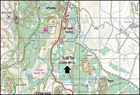
Tel Abel Bet Maacah is located in the Galilee panhandle, c. 2 kilometers south of Metulla (Figure 1).
The Purpose of the Project
This planning project was intended to examine the feasibility of establishing an educational- archaeological park on Tel Abel. It includes an archaeological-historical overview of the site and a preliminary proposal for conserving and developing the tell.
Site Description
Tel Abel (“Bet Maacah” is its biblical name) was inhabited from the Early Bronze Age until the twentieth century CE. The tell is situated on a prominent calcareous spur that slopes southward toward the Hula Valley and is encircled on three sides by Nahal ‘Iyyon. There are two peaks on the spur that rise c. 50 meters above the surrounding area. At the foot of the tell is a moderate area with an abundance of seasonal springs that were used for irrigating the crops that were grown there throughout history.
The tell is physically detached from other sites around it. Nevertheless, it can be clearly seen from the observation points arranged along the ridge to the west of it: Dado Lookout, Mizpeh Banya and Mizpor Rotem. There are several sites of interest in the communities surrounding the tell, including heritage sites such as the Tel Hai courtyard, undeveloped archaeological sites and museums. There is also a popular trail near the tell which leads to Nahal ‘Iyyon and the Tanur waterfall.
Historical and Archaeological Description
The Bronze Age – in the Early Bronze Age a Canaanite city was situated on the tell, and a fortified city was built there afterwards in the Middle Bronze Age. During the Late Bronze Age it was a major city. The city is mentioned in Egyptian writings as one of the Canaanite cities that the pharaoh Thutmose III conquered.
Tenth century BCE – we know from the biblical narrative that Sheba Ben Bichri, who led the revolt against King David, hid there. He was put to death in order to stop the siege that Joab Ben Zeruiah, the commander of David’s army, placed on the city (2 Samuel 20).
Early ninth century BCE – the Israelite city of Abel Bet Maacah was conquered by Ben-Haddad, king of Aram, at the request of the king of Judah who sought revenge for an attempt by the Israelite king to conquer Judah (I Kings 15).
Eighth century BCE – the city was conquered by Tiglath-Pileser III, king of Assyria, following a conflict with Israel-Judah-Aram (II Kings 15 and in Assyrian documents from the time of Tiglath-Pileser III).
A large city was located there in the Hellenistic and Roman period.
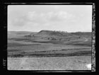
The first mention of the Arab village of Abil al-Qamh (the meaning of the Arabic name is "Meadow of Wheat") is from the thirteenth century CE by the Arab geographer Yaqut al-Hamawi (Figure 2).
On the eve of the 1948 War of Independence some 360 persons resided in the village in mud brick, stone and concrete structures, most of whom made their living working the land. The wheat and barley fields surrounded the built-up area of the village. Owing to the abundance of water in the valley at the foot of the mound the local inhabitants used to call the village Abil al-Mayya (meaning “The Meadow of Water”). The village was abandoned probably after the fall of Arab Safad.
TOMA 8 – National Outline Plan 8 is the plan that was adopted in 1981 for national parks, nature reserves and scenic reserves, and in which Tel Abel was designated a scenic reserve.
At the top of the mound today is an IDF observation post where there are build, outdated communication trenches and fortified positions.
Evaluation of the Cultural Significance
Tel Abel is a cultural landscape site. Its uniqueness as a biblical tell (as of the time of this work) lies in the fact that it was never excavated and as such is one of the few remaining untouched mounds in the country.*
Abel Bet Maacah is mentioned in the Bible three times in descriptions of political events, and internal and regional conflicts that occurred 3,000 years ago. The city is also referred to in extra-biblical sources.
There are seasonal concentrations of flowering on the tell, some endemic such as the Nazareth iris, which is an endangered species.
Conservation Considerations Regarding the Site and its Development
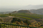
· The site offers an impressive vantage point that looks out over the surrounding area. From the northern peak there is a panoramic view of the Hula Valley.
· Concentrations of flowers on the tell and its slopes, including an endemic iris species.
· References to the place in biblical and historical sources create an opportunity to discuss political and military moves both then and now.
· The site is topographically separated from the Nahal ‘Iyyon Reserve and the town of Metulla by Nahal ‘Iyyon.
· One can easily reach the foot of the tell by car.
· Hikers passing through the groves surrounding the tell when the fruit is ripening is likely to cause damage to the farmers.
The Plan’s Recommendations
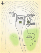
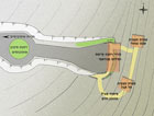
The preliminary plan proposes operating two sites: one at the top of the tell and the other at Mizpeh Rotem which looks out onto the tell. The plan also calls for developing the landscape at the top of the tell including arranging the existing IDF infrastructure there, parking, a covered observation point, signage and preparing a walking trail for visitors which passes through the area where the flowers bloom (Figs. 3, 4).
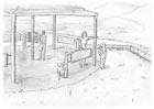
At Mizpeh Rotem – the lookout is located on the Menara Ridge south of Metulla and offers the optimum view of the western part of Tel Abel, the Hula Valley, the Golan Heights and Mount Hermon. The plan includes widening the road so as to allow buses to pass through, covering the existing observation point with a roof, arranging panoramic signage and adding a lower trail with observation posts and an explanation about the Tribe of Naphtali, as well as a general explanation regarding the history of Tel Abel Bet Maacah (Fig. 5).
Planning Recommendations
1. Avoid excavating on the mound.
2. Create a tie between the residents of Metulla and the site and the local history through cooperation in the planning and implementation processes.
3. Explain the story of the city Abel Bet Maacah to the public and emphasize the internal and regional struggles of the people of Israel in biblical times.
4. Expand the development at Mitzpah Rotem, in order to tie it together with the tell.
5. Position the tell as a place where large concentrations of flowers blossom and as an interesting lookout that should be visited during a trip to the north (Fig. 6).
Sources
Mazar B. 1975. Cities and Districts in Eretz-Israel. Jerusalem. Pp. 201–202 (Hebrew).
National Outline Plan for National Parks, Nature Reserves and Scenic Reserves - Plan No. 8.
* Update: In 2013 the first archaeological excavation at Tel Abel Bet Maacah was conducted on behalf of the Hebrew University of Jerusalem, directed by Nava Panitz-Cohen and Ruhama Bonfil of the Institute of Archaeology of the Hebrew University and Bob Mullins of Azusa Pacific University in California.
----------------------------------
Summary: Vered Matityahu, February 2016
To view the figures, click on the figure caption
|