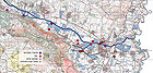
| Nahal Harod |
| Nahal Harod River Basin |
| Survey and Preliminary Planning |
| Orderer | The Southern Jordan Drainage Authority |
| Duration | December 2004- January 2005 |
| Implemented by: |
Arch. Yaara Shaltiel
Yoram Sa'ad
|
The aim of this project was to formulate a plan for the conservation and renovation of the landscape in the Nahal Harod river basin.
The plan includes a proposal for preserving the archaeological sites in the vicinity of the river, creating a visitors’ path in a landscape and cultural context that emphasizes the settlement continuity in the region throughout history by highlighting the multitude of tells located there, and the renovation, conservation and development of the ancient and historic agricultural water installations situated along the river.
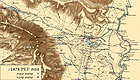
The Nahal Harod basin is a narrow valley slightly above sea level, with an abundance of springs and streams that drain into one river that in turn flows into the Jordan River. The basin is located between the Gilboa Ridge, rising to the south, and the Issachar Heights. In the Bible the Harod Valley is referred to as the Jezreel Valley. Owing to its strategic location important military campaigns and historic battles were fought there, some of which are mentioned in biblical narratives and are associated with the river and the surrounding settlements, among them The Song of Deborah, Gideon at ‘Ein Harod, the death of Saul at Bet Shean, and Naboth’s vineyard.
The valley was continually settled throughout all of the historic periods and served as one of the important routes from the Jordan River into the country and on towards the coastal plain. Throughout history numerous roads ran through the valley, from the Roman roads that connected Caesarea and Legio to Bet Shean (Scythopolis) and on to Transjordan in the East, to the Valley Railroad, dating to the end of the nineteenth century, which linked the interior of the country with the port in Haifa.
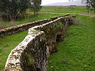
The abundance of water in the valley resulted in increased settlement there that was based on extensive and diverse agriculture for which numerous water installations were built such as channels, dams and bridges. The abundance of water could have become a hindrance for the settlements if the residents did not maintain the drainage systems, without which the valley would have become a swamp.
The conditions of the drainage basin created a unique combination of a valley planted with grain with the topographic conditions that are convenient for utilizing water power in flour mills and in crushing sugar cane. Sugar was the principal crop in the Bet Shean region at the time when the Crusaders and Mamluks ruled the country. In 1878 the British (PEF) mapped some 35 mills (some of them ruinous) in the river’s drainage basin. By that time sugar was no longer being produced there and the mills that had once been used for crushing and refining sugar had been converted to milling flour or were abandoned.
Running the length of the basin is a unique and wide variety of mills in various states of preservation. Some are single mills, such as at Ganei Huga, and some are components in a series of water installations, like the complex at ‘Ein Shoqeq that includes a raised mill pond, the remains of a dam and a sluice mill, irrigation ponds, irrigation channels and a unique flour mill equipped with three tower-like structures. The complex comprises remains that date from the Roman period until the time of the British Mandate and an irrigation system that is in use to this very day.
In the region beyond the river, next to Bet Shean, there is an impressive collection of flour mill remains and a series of bridges that were built, destroyed and renovated throughout history. In the Mamluk period Khan Ahmar was constructed which is one of the largest khans in the country. All of these bear witness to the importance of the city of Bet Shean and how strategic its location was in previous eras.
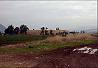
The increase in settlement throughout history elsewhere in the drainage basin is manifested by the numerous small tells that situated next to springs and rising up above the valley. These tells enhance the landscape in that they can be seen from afar and they offer a commanding view over the surrounding countryside. Some tells, such as Tel Yosef and Tel Sokha, were utilized during the early years of the Zionist settlement.
Level of Preservation
Numerous sites in various states of preservation are located along the drainage basin.
Agricultural Installations. The state of preservation of the installations scattered the length of the basin is not uniform. Apart from the environmental conditions, their preservation is also a function of the continued use of the installations and the extent to which the settlements, the agriculture and the roads around them are developed. The installations adjacent to and inside the Bet Shean National Park are quite well-preserved thanks to the fact that they were taken care of or used until the middle of the twentieth century.
Tells. While some excavations of very limited scope have been conducted at some of the tells, most of the tells in the valley have not been excavated at all. Khan Ahmar, which is located next to the Bet Shean industrial zone, is in a ruinous state; the vaults in its exposed eastern wing are unstable and are being destroyed.
The Project’s Recommendations.
Our recommendations are divided into a general proposal for the systemic treatment of all of the tells and specific recommendations for each site/ water installation/ complex of water installations.
Tells. The tells in the river basin will be treated in a uniform manner, with the aim of intensifying their visual experience and their perception as an assemblage. The recommendations in this regard include: 1) planting the tells with the same shade of wild flowers in order to accentuate them during the winter and spring seasons, particularly when observing them from the Gilboa Ridge; 2) erecting a flat circular observation platform at the top of each tell that will be comprised of two concentric rings– one for general observation, the other to view the tells, sites and historic roads from the periods analogous to the tells, including distance markers; 3) uniform directional signage; 4) signage on the tell for the purpose of explaining and illustrating the historical events that occurred there; 5) organizing activities using an education kit that will be distributed in the information centers.
Water Installations. In our recommendations regarding the treatment of the water installations we refer to four geographic regions. Our recommendations are as follows:
Upper Nahal Harod. The finds in this region include the remains of two flour mills adjacent to Nahal Harod.
· Renovation and conservation of the sluices, aqueducts and tower-
like structures.
· Prepare a circular path between the mills.
· Prepare a rest area in the shade of the eucalyptus trees.
· Post signage with explanations and illustrations.
-
The ‘Ein Shoqeq Complex.
· Renovation and conservation of the entire complex.
· Restore the flow of water throughout the complex.
· Design a path through shaded areas for summer visits with the
possibility of allowing the visitors to enter the water.
-
Bet Shean. The finds include a group of flour mills and two bridges.
· Renovation of the mills and their conservation according to their
level of preservation.
· Restore the flow of water in the twin mill.
· A proposal for renovating the bridges and using them as additional
entrances to the national park.
Khan Ahmar.
· Eliminating the hazards posed by the eastern vaults
· An archaeological survey to study the khan’s components.
· Conducting an excavation for the purpose of facilitating the display
and use of the structure.
· Conservation, renovation and development integrated with private or
public projects.
-
The Jordan River Outlet. The flour mill at Ganei Huga.
· Conservation and renovation of the structure.
· Stabilization of the vault and the removal of hazards.
· The operation at the site can be illustrated from the flow of water all
the way through to the milling process.
The sites that were surveyed add a cultural-archaeological dimension to the proposed track. They portray an aspect of the cultural landscape in this natural environment, allowing us to have a glimpse at the farming culture of previous eras. Their renovation, conservation and integration in walking paths intended for leisure and recreation, and within the framework of educational activities, will contribute to the enrichment of the visitor’s track and will contribute to the preservation of the built cultural heritage of Israel.
To view the figures, click on the figure caption
|