Values and Aims
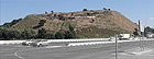
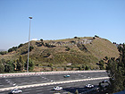
We surveyed Tel Yoqneʽam in January 2008, when we began preparing a program for the conservation and development of the site. In the twenty years that elapsed since the excavation the remains were beginning to be covered over again and they could hardly be recognized. Having read the excavation publication we understood the great cultural value that lay buried in the remains of the fortifications dating to the tenth–eighth century BCE, the time of the Iron Age 2, also called the Period of the Monarchy.
Based on the condition and scope of the remains a significant budget was required for conservation, and therefore we postponed the work in this region until a later stage in the program. Nevertheless, in order to present the values of the tell from the biblical period, we placed thematic stations along the path around the tell which deal with the following topics: the Tribe of Levy – which was given the city when the country was divided amongst the twelve tribes, the structure of the city during the period of the monarchy and the roads that passed along the foot of the tell. At the request of the district archaeologist, Tzach Horwitz, we added a station that looks out over the fortifications from which in the first years one saw mainly thorns…
The conservation and development plans accompanied by extensive educational activities were implemented as the years went by. In 2012 an initial budget was obtained for commencing conservation work on the fortifications with funding provided jointly by the Yoqneʽam municipality and the heritage project of the Prime Minister’s Office. Recently the Government Tourism Company jointed the effort by financing the planning of the visitors center and the illumination of the tell in general, and that of the fortifications in particular.
State of Preservation
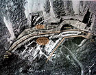
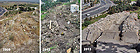
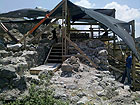
Only scant remains of the casemate wall have survived. At the time of the excavation it was on the first line of the slope. The deep excavations that were dug at the foot of the wall and the absence of conservation resulted in much of the casemate remains collapsing over the course of twenty years. Therefore most of the conservation and development work relate to stabilizing and presenting the remains of the double city wall. This wall is better preserved but parts of it that were still in place at the end of the excavation have also since collapsed and tumbled to the bottom of the slope. The intensive excavations along the slope beneath the fortification’s foundation also resulted in damage to the side of the tell.
Planning
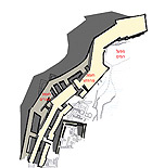
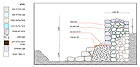
The planning proposes a circular route inside the double city wall from an existing observation point in the western part of the excavation to an observation point in its east, accompanied by signage and illustration. The stabilization work includes covering over parts of the excavation and filling in the tell where parts of the slopes are missing. The conservation work includes restoring a large part of the outer surface of the fortification’s exterior wall, most of which has collapsed in the years since it was exposed. The upper courses of the city wall were apparently built of mud bricks, several of which were found in the debris. They survived because they were fired in the conflagration that occurred at the time the tell was destroyed. We decided on the size of the mud bricks and the manner of the construction by a comparison with finds from the same period at Tel Lachish and Tel Megiddo.
In accordance with the cultural values of the fortifications and expressing the icon, we dealt extensively with the appearance of the fortifications surrounding the tell. We consider it extremely important that the sequence of the city wall’s contour line be emphasized. We examined numerous options for highlighting this sequence by means of conservation, restoration, and with modern elements. At this point no budget has been found for conserving the entire sequence of the city wall. The section of fortifications that surrounds the water system was excavated mainly on its inside, so that even after all of the conservation work is completed it will be very difficult to distinguish it from the junction. Although we put forth several proposals for emphasizing the sequence we prefer at this juncture to invest as much as possible in the conservation work and with the exception of illuminating the line of fortifications we have postponed making a decision in this matter.
Currently the first stage is ending which constitutes about a third of the all the work. For further conservation work in the future we recommend excavating the water system and connecting it to the visitor’s route.
Implementation
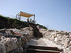
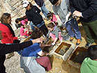
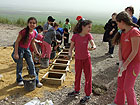
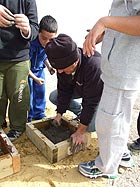
The cost of implementing the conservation work and developing the proposal is extremely high and it will therefore be done in stages. So far about a third of the entire work has been completed, which includes c. 30 meters of the double wall and a few remains of the casemate wall. The scope of the construction was quite large and included rebuilding the outer surface of the walls and completing one to two courses of the wall according to the preserved height of the core of the walls. We restored a small segment of mud bricks at the southern end, close to the section. The bricks were prepared by the city’s school children as part of the educational activity conducted on the tell. In the corridor formed between the double city walls we removed any dangers so as to ensure safe passage for the public, and the steps going down are built of railroad ties. Upon completion of this stage one will be able to descend from the observation point and proceed for a distance of 30 meters that were rehabilitated and return.
These days, simultaneous with the rehabilitation of the fortifications, we have begun planning a visitors center to be constructed at the southern foot of the tell. Finding a budget for conserving and developing a biblical tell is not obvious. Nevertheless, the cooperation and commitment of the Yoqneʽam municipality headed by Simon Alfasi and the Israel Antiquities Authority have resulted in raising funds and an extensive investment in conservation, development and education. We wish to continue this successful collaboration and are hopeful that in the coming year we will continue with the rehabilitation of the fortifications until the entire visitor’s route is opened.