|
|
 |
Standards and Tools
From the Archaeological Survey to the Conservation Inventory
Yael Alef
The importance of the archaeological survey was recognized in the country fifty years ago and since then it is one of the most important tools for obtaining information about antiquities sites. The information that has been gathered in the past one hundred years of archaeological research in Israel is today on file in the Israel Antiquities Authority inventory of archaeological sites and is used to manage them. In my work in the Israel Antiquities Authority Conservation Department I have to deal on a daily basis with the management of archaeological resources and I recognize the importance of the information as a basis for the conservation of sites. But conservation surveys, unlike archaeological surveys, have not yet been established as part of the activity conducted by the Israel Antiquities Authority. From time to time conservation surveys are performed as an ad hoc response to planning needs; however, the gathered information is not translated to a “conservation leyer” in the inventory for the management of Israel’s archaeological heritage. For example, there is no classification system for scheduling antiquities sites for conservation, assessing the extent of the sites that were destroyed in salvage excavations over the years or drawing information about resources for future archaeological research. In addition, we do not possess a database containing information regarding the threats to sites, the sites’ physical condition, their cultural value and planning potential.
|
The issue of archaeological site conservation is complex because of the tension that exists between archaeological research on the one hand and the need to preserve the remains on the other. The archaeologist exposes the site, studies it and renders it value, while at the same time he destroys the remains during the excavation. In order to derive the maximum amount of information inherent in the site, the archaeologist strives to reach bedrock. In doing so this is likely to impact not only future research but also any possibility of conserving the site and presenting it to the public.
Rescue from Salvage Excavations
Salvage excavations, which are conducted for the sake of development, are an extremely destructive factor. The increase in the number of archaeological excavations in the country from 2,200 excavations in the 1990s (Kletter and De Groot 2001) to 2,900 salvage excavations in the past decade (2004–2013) [1] llustrates the problem of safeguarding archaeological reserves for future generations. In fact, there are almost no large sites that have not been excavated in Israel and dozens of smaller sites are being excavated every year and are ‘erased’ from the map. That being the case then we must ask, how much is ‘rescued’ in ‘salvage’ excavations?
|
The method of salvage excavations was developed in response to the extensive destruction of archaeological sites in the wake of new construction in the historic city centers in the years following the Second World War in Europe and the United States. Ironically, more sites were destroyed then as a result of the post-war development than were destroyed in the war itself. The situation reached a point that in 1972 the Council for British Archaeology published a report entitled "The Erosion of History" , in which it warned that if the accelerated pace of development continued and salvage excavations remained in the same format then all the archaeological reserves in the historic cities in Great Britain would be lost in less than two decades. The criticism regarding salvage excavations resulted in seeking out new courses of action that would allow preserving as many sites as possible for the benefit of future research and use.
Solutions and Models for Heritage Management
As a response to the problem posed by salvage excavations, Lipe (1974) proposed a model for managing the archaeological heritage in the United States. This model is based on the understanding that archaeological research is predicated on an exhaustible resource that is rapidly being depleted. In order to allow the continuation of research in the future, he wants to slow down the depletion of the resource and treat it sparingly. To do this, Lipe calls on archaeologists to be involved in all aspects of archaeological resource management and not limit themselves to research alone. Lipa proposes three courses of action:
|
1. Educating the Public – public support and promoting an appreciation for archaeology constitute the basis of the model. This is meant to prevent vandalism and create a social value by which archeology illuminates a cultural perspective of man's place in the world.
2. The Involvement of Archaeologists in Planning - Lipa notes the absence of systematic planning-oriented surveys and inventories, as well as the importance of involvement in the planning stages rather than salvage excavations that are conducted after the decisions were taken and in a manner completely separated from planning.
3. Archaeological Reserves - a conservation strategy that seeks to safeguard the resource by designating "archaeological reserves". No zoning changes will be permitted in these reserves and they will subject to strict supervision. The selection of sites to be designated reserves calls for special criteria, along with the usual criteria, such as monumentalism and uniqueness. Lipa proposes preserving representative sites from each type for future research.
Over the years these principles have found expression in the archaeological heritage inventories of several countries around the world.
|
What will be Included in the Inventory? Selection and Assessment of Archaeological Sites for Preservation
The change in the archaeological emphasis – from maximizing the potential research to preserving the remains in situ – requires a system for selecting and assessing archaeological sites and their integration in the planning processes (Pokotylo 1976). Selection is primarily concerned with distinguishing between an archaeological site and an archaeological heritage site; the difference stemming mainly from the value we attribute to the site and the future chosen for it. Heritage sites are those places we ascribe importance and choose to preserve and bequeath to future generations. For example, most of the archaeological remains exposed today in salvage excavations are not granted the status of heritage sites, but are destroyed due to the demands for development. The existing legislation in Israel does not define criteria for the classification of archaeological sites as heritage assets. The designation of archaeological sites as antiquities under the Antiquities Law of 1978 is based solely on the age of the asset, that is to say, any archaeological relic prior to the year 1700 CE. However, designating the site an “antiquity” does not grant it the status of a site slated for conservation. The conservation inventory therefore is designed to identify heritage sites from amongst all of the antiquities sites and allow for their protection, conservation and development. In order to decide which sites to include in the conservation inventory (and thereby also decide which of the sites will not be protected and will be lost) it is necessary to determine appropriate criteria for their classification and assessment. The criteria used in England for example are: a site that is characteristic of a particular category or period, rarity, documentation or information about the site, group value, state of preservation, fragility and vulnerability to risks, diversity and potential for future information (DCMS, UK, 2010). In addition, specific criteria were determined for archaeological sites depending on the characteristics of categories ranging from agriculture to burial, government, cult and industry (English Heritage, 2012).
|
What Information does the Inventory Require for the Purpose of Conserving Sites?
1. Information for Planning Purposes – an inventory of archaeological sites, such as the IAA database, is designed for the research and the protection of archaeological information. However, as stated, this information does not provide adequate protection for the archaeological resource. In the wake of recognizing the sites importance as a planning resource, namely the need to integrate them in planning as a means to minimize destruction, while at the same time allowing the full cultural potential inherent in them, planning information is also added to the conservation inventory.
2. Risk Assessment - the increasing awareness of threats to archaeological resources and their vulnerability to the ravages of climate, air pollution, natural disasters, robbery and wars, together with a bolstering of conservation approaches that call for preventive conservation, have raised the need to prepare for these risks.
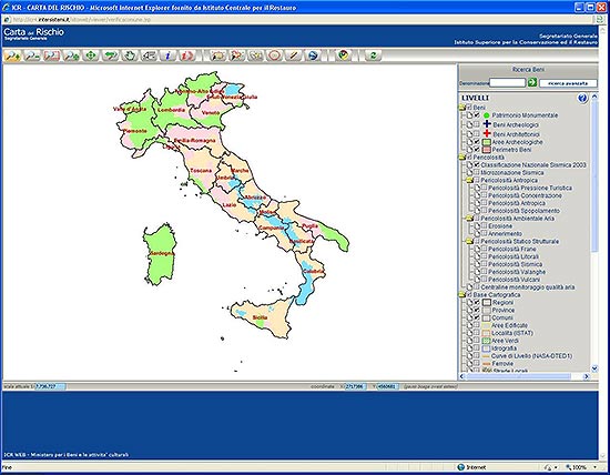
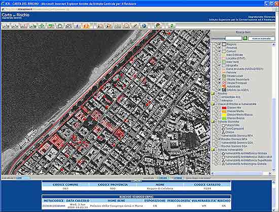
In 1992 the Cultural Heritage Risk Map Project was inaugurated in Italy, which is an information system that allows setting priorities for conservation and maintenance on the basis of risks assessment to the heritage (see Figures 1, 2). This concept has also been implemented in the Jordanian antiquities inventory, which focuses on identifying risks as a tool for monitoring, protecting and managing heritage. This is also the case regarding the list of endangered heritage sites in England (Heritage at Risk) where for example it was found that 38%(!) of the designated sites had been damaged in 2013 by cultivation. This activity has not gone unnoticed by the Israel Antiquities Authority either, which initiated together with an interministerial steering committee on earthquake preparedness, a survey of archaeological sites that are at risk of earthquakes. The survey examined the structural condition of the remains against the seismic threats in order to assess the risk level of the sites (see Figure 3). The survey found that a significant number of buildings are in critical condition. This means that these structures will probably not survive the next earthquake if action is not taken to stabilize them.
|
Figures 1, 2. The distribution of earthquake risks in Italy allows for preparedness at the national level. From: The Risk Map of Cultural Heritage in Italy.
|
Figure 3. An analysis of the seismic threats at Deir Aziz performed by the Geological Survey of Israel as part of a survey of earthquake risks to archaeological sites. Risk level was derived based on a calculation of the threats and the site’s degree of vulnerability. Courtesy of Michael Cohen, Israel Antiquities Authority.
|
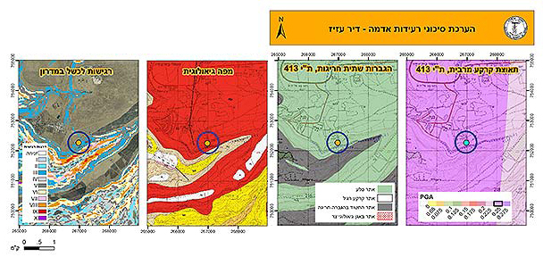
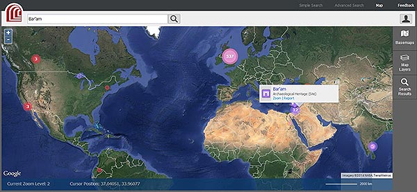
3. Sharing Information and Public Awareness - Today, in the “Age of web culture", the inventory of heritage sites also plays a central role in information sharing, education and raising public awareness. The Archaeological Survey of Israel website is one example of this. Interactive systems, like the historical inventory of Los Angeles (Survey LA) invite the public to propose new sites and share information about existing sites (see Figure 4). Among the current trends there are geographic information systems based on open source software, such as Arches, which is designed for inventories and heritage management, and enables adaptation for the specific needs of each inventory and sharing of information (see Figure 5).
|
Figure 4. The Los Angeles survey site emphasizes its call to the general public to learn, identify sites, participate and become involved in the survey. The design of the home page reflects the role of the survey as a tool for sharing information, educating and public awareness.
|
Figure 5. The Arches system allows the public to share information about heritage sites around the world, in addition to creating databases adapted to the specific needs of different kinds of entities and inventories.
|
In Preparation of the IAA Conservation Inventory
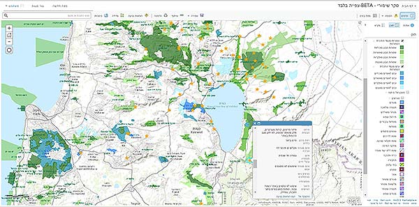
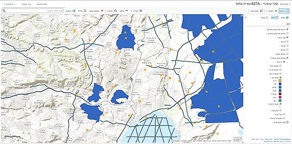
When we embarked upon building the database for the Saving the Sites project, initiated by the Israel Antiquities Authority and the Heritage Project in the Prime Minister’s Office, the question arose: What information is required for the conservation inventory? We discovered that the lack of information is the main obstacle to conserving sites. Of the dozens of ancient synagogues in the Galilee only a few are actually known to the public and the local authorities have no information about their conservation needs and development potential. Therefore, we developed a conservation inventory for archaeological sites in cooperation with the IAA Information Technology Department, which is based on the geographic information system – ESRI ArcGIS Online. This system serves as a tool for making decisions regarding the manner of intervention at each site, from an overall perspective of the region (see Figures 6, 7). This inventory is a pilot for infrastructure management, monitoring and long-term maintenance. The system’s features were defined in accordance with the information required for the conservation and maintenance of the sites, and they currently include statutory information, information about the physical condition of sites and the risks, as well as a cultural assessment of each site. The next step will be to bring the information in the inventory to the attention of the general public as part of the measures needed to raise the awareness of the local community.
|
Figure 6. Inventory map of the synagogues in the Galilee. The sites are marked against the background of the National Nature and Parks Reserves as an example of the kind of planning information and stakeholders. A detail of the survey card of the Hamat Gader synagogue can also be seen, which contains information that was collected regarding threats to the site. From: Save the Galilee Synagogues Project, Conservation Department, Israel Antiquities Authority (2014).
|
Figure 7. Inventory map of the synagogues in the Galilee. The sites are marked against the background of military firing zones and seismic fault lines in order to analyze threats to the sites. From: Save the Galilee Synagogues Project, Conservation Department, Israel Antiquities Authority (2014).
|
Conclusion
The archaeological survey is an efficient, fast and inexpensive tool for gathering information about remains located on the surface (Baruch 2014). As a condition for effective protection of the sites this information should be supplemented with data from the conservation survey in the “conservation layer” in the inventory. A database such as this will make it possible to integrate archaeological sites in determining the different land uses at all levels of planning. In addition, the inventory will allow locating and monitoring sites that are at risk, and at the same time identifying potential for development and setting priorities for the conservation of sites and their development in local and national action plans. Without a doubt, this is one of the major challenges currently facing the Israel Antiquities Authority and the Conservation Department in managing Israel’s built cultural heritage.
*My thanks to Raz Efron for his helpful comments on the article.
Notes
[1] The data was provided courtesy of Zohar Ya‘aqobi, of the Management and Supervision Department of the Israel Antiquities Authority.
|
Bibliography
Kletter R. & De Groot A 2001. Excavating to Excess? Implications of the Last Decade of Archaeology in Israel. Journal of Mediterranean Archaeology 14(1):76–85.
Lipe W.D. 1974. A Conservation Model for American Archaeology. Kiva 39(3/4):213–245.
Pokotylo D. 1976. Archaeological Resource Inventories: Two Case Studies from the British Columbia Interior Plateau. Canadian Archaeological Association Bulletin 8:147–161.
Reich R. 1987. The Archaeologist’s Dilemma: On Some Aspects of Archaeology as a “Destructive” Scientific Discipline. Old Cultures in New Worlds. Eighth ICOMOS General Assembly and International Symposium. Program Report – Compte Rendu (1009–1015) Washington: US/ICOMOS. Retrieved: http://international.icomos.org/publications/wash133.pdf
|
-------------------------
September 2014
-------------------------
|
|
|
|
|