| Tel Chinnereth |
| Tel Chinnereth |
| A Program for Tourism Development of the Site |
| Orderer | Government Tourism Company |
| Duration | May-November 2013 |
| Implemented by: |
Eran Mordohovich
|
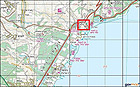
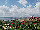
Tel Chinnereth (in Arabic:Tell el-‘Oreimah; in Hebrew: Tel Kinnerot), on the northwestern shore of the Sea of Galilee, is an archaeological tell where remains of the city of Chinnereth are located (Fig. 1). The tell is situated in an area rich in archaeological and historical sites, many of them being of great importance to Christianity. From the tell one has a spectacular view of the surrounding area and a panoramic view of the Sea of Galilee (Fig. 2).
The tell extends across an area of c. 100 dunams. The top of the tell, consisting of two peaks and a saddle, rises to an elevation of c. 135 m below sea level (c. 75 m above the level of the Sea of Galilee). Its strategic location at the edge of the lake, between two fertile valleys – the Bethsaida Valley and the Kinnerot Valley – and next to the ancient Via Maris, rendered it a desirable place to be settled and an important city for thousands of years from the Early Bronze Age until the Hellenistic period (3000–100 BCE).
Most of the southeastern area of the tell is owned by the German Catholic Church. Numerous archaeological excavations have been conducted there but it is not freely accessible to the public today. On the southern fringes of the tell is the church’s guest house, which was built as an addition to the original hostel that was constructed at the end of the nineteenth century. The tell’s southwestern part lies within the precincts of the Sapir Site, and it too cannot be entered.
The tell is today located in the Kefar Nahum National Park. This national park and numerous sites in the immediate surroundings are the focus of Christian pilgrimage and tourism. Tel Chinnereth is the most important biblical site of this region. The Trail around the Sea of Galilee and the Gospel Trail pass through part of the tell.
The purpose of the project, as expressed in this program, is to preserve the values of the place, enhance the scenic experience and reveal the history of the site to visiting public. All this is to be done by connecting the tell to the Gospel Trail, planning visitor routes at the site and preparing shaded observation points, displaying the archaeological remains and providing explanatory information about them.
Historical and Archaeological Description
Remains from the following periods were uncovered in archaeological excavations carried out on the mound: Neolithic, Chalcolithic, Early, Middle and Late Bronze Ages, Iron Age, as well as the Persian and Hellenistic periods.
Tel Chinnereth was first documented by the British survey expedition (Palestine Exploration Fund) in 1881 and is referred to as Khirbat el-‘Oreimah. In an archaeological survey performed by P. Karge in 1909–1911, an Egyptian scarab bearing the name of Queen Tiye, wife of Amenhotep III, was discovered at the site.
In the 1920s, G. Dalman and W.F. Albright were the first to identify the site with the biblical settlement of Chinnereth.
Up until the 1980s several excavations and probes were conducted on the tell which uncovered finds from different periods. Since the 1980s extensive excavations have been carried out on the peak and along the eastern slope that descends down to the Sea of Galilee, first by an expedition headed by Professor Volkmar Fritz and later by the Kinrot Regional Project expedition (KRP), directed by archaeologists Stefan Münger, Juha Pakkala and Jurgen Zangenberg of the Universities of Bern, Helsinki and Leiden respectively.
Researchers in the excavations in the 1980s (Gutenberg University, Mainz, Germany) focused their work on the top of the tell (Areas A–F) where they discovered finds and remains that mainly date to the Iron Age 2. From 1993 to 2001 Volkmar Fritz continued excavating on behalf of the German School of Archaeology in Jerusalem, primarily on the lower part of the tell. Since 2003 the KRP expedition has been excavating in that area.
In the 1980s and 90s trial excavations and archaeological surveys were conducted on behalf of the Israel Antiquities Authority and the Tel Aviv University in the vicinity around the tell.
Since the year 2000 conservation measures, mainly implemented by conservator Kimi Maman, have been carried out simultaneously together with the excavation of the site.
History of the Site
The settlement was first mentioned in Egyptian sources of the New Kingdom from the time of the XVIII Dynasty, in a list dated to 1460 BCE, as a settlement by the name of K-N-N-R-T which was conquered by the pharaoh Thutmose III. The city is also mentioned in the Book of Joshua (19:35) as one of the fortified cities of the territory of Naphtali: “And the fortified cities were Ziddim-zer and Hammath, and Rakkath, and Chinnereth”.
In the Early, Middle and Late Bronze Ages (3000–1300 BCE) Chinnereth was a fortified city.
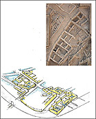
In the Iron Age 1 (eleventh century BCE) this was the largest city in the north of Israel – a fortified Canaanite city protected by a wall 11 meters thick. Numerous finds indicative of a developed urban culture were discovered on the eastern and lower part of the mound. The easternmost building in this area is trapezoidal, measuring c. 30 meters long by c. 13 meters wide. This structure, the remains of other buildings and the urban complex that were revealed indicate a planned settlement with a developed architectural culture (Fig. 3). The city was probably destroyed in an earthquake that struck the region in c. 950 BCE.
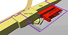
In the Iron Age 2 (ninth and eighth centuries BCE) the area of the city was reduced to just the top of the tell (the acropolis; Fig. 4). The city at this time was small and well-fortified. The antiquities that have survived from the period include remains of the city wall, a gate and towers, public buildings and storerooms. Among the prominent remains are a gatehouse and an adjacent colonnaded rectangular building used for storage where remains of grain were found (Fig. 5).
Other remains were uncovered on the southern peak at the top of the tell and on the saddle between the two peaks, on the western side. These remains are barely visible today due to their poor state of preservation. On the eastern slope of the northern peak one can still discern remains from the Iron Age, which are also poorly preserved.
An Evaluation of the Site’s Cultural Significance
Historical Values:
The tell is evidence of a developed settlement that was situated at a crossroads and controlled its surroundings. This intersection became a strategic meeting point between ancient cultures and regional political powers. From the meager historical evidence we possess Chinnereth was presumably a major settlement in the region, which was on a par with other important cities in the north of Israel, such as Hazor and Megiddo.
In addition to being situated at a crossroads, its proximity to the Sea of Galilee and the favorable living conditions provided it with a good basis from which the settlement could develop. Tel Chinnereth is evidence of the existence of an important Canaanite city that became an Israelite city in the northern Kingdom of Israel. The tell is an example of the story of the entire region in the Bronze and Iron Ages. This story distinguishes Tel Chinnereth from the archaeological sites in its vicinity, which are generally characterized by their historical connection to the time of the Second Temple and subsequent periods.
Scientific–Archeological Values:
Remains of the Iron Age 1 city, which were in an extraordinary state of preservation because of the city’s destruction by an earthquake and the absence of later construction on these remains, make it possible to carry out research and better understand urban life in this region at this time. Many other artifacts from the tell, such as the remains of food and tools, add to this understanding. The destruction of the lower city and the reduction of its size following the earthquake provide evidence of changes that occurred in the area at the time.
Architectural Values:
Buildings and walls of impressive size and complexity are located at the site. Examples of this are the ancient northern city wall more than 11 meters thick which dates to the Bronze and Iron Ages, a single chamber gatehouse with a paved street and an adjacent storeroom. Remains of the buildings and the streets in the lower city attest to an advanced urban culture and the high degree of planning and implementation capability on the part of its inhabitants.
Landscape Values:
The location of the mound near the Sea of Galilee and its scenic presence created a significant landmark in the region. From the top of the tell one can look out on the Ginnosar Valley and the Bethsaida Valley, to Highway 90 that passes along the ancient route around the Sea of Galilee and on the Mount of Beatitudes to the north. From this vantage point the entire Sea of Galilee is visible and the wealth of sites around the tell is revealed.
The State of Preservation
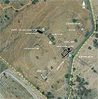
The excavations that were conducted on the tell over the past thirty years left behind remains that are in various states of preservation; many of the finds and the excavation pits were filled in so as to prevent damage to the finds and danger to visitors.The remains that were left exposed at the site include (Fig. 6):
A tower and city wall to the north (A) – remains covered with vegetation, part of the city wall and the exposed walls on the hillside.
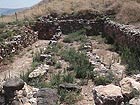
A storeroom, the city gate and southern city wall (B) – conservation intervention was carried out in this area in 2004. The walls were in a problematic state of preservation requiring preventive conservation such as pointing up the joints with mortar and sealing the tops of walls. The earthen balk north of the gatehouse, below which is the continuation of the gate, is subject to erosion and disintegration (Fig. 7).
Remains of the city wall and the corner of the wall on the southern hill (C) – several stones are visible on the surface and remains of the corner of the wall are discernible.
The saddle between the peaks – apart from the aforementioned gate area, there are two other concentrations of antiquities in this area.
1. Northern city wall (E) – foundations of the Bronze Age city wall and the upper part of the wall from the Iron Age. The parts of the wall that are exposed are in an advanced state of deterioration.
2. East of the city wall (D) – building remains that were excavated in the 1980’s. A tree is growing inside the building and the walls are in a state of deterioration.
The Proposed Planning Elements
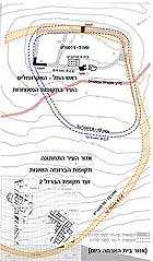
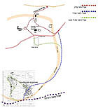
The landscape and historic values of Tel Chinnereth and its accessibility constitute the basis for the development of the site and opening it to the public. The proposed plan will offer appropriate conditions for visiting the place, for observation and conveying the story of the place and of the archaeological remains located there (Fig. 8).
The main elements of the proposed plan are as follows:
• Making the tell accessible from the northwest (connecting it to the Gospel Trail) in order to emphasize its elevation and underscore the impressive landscape.
• Including the tell as a landmark along the Gospel Trail.
• Preparing a comfortable and meaningful path that passes through the archaeological finds.
• Conserving the antiquity sites along the proposed path will make understanding the archeological finds easier and provide visitors with a safe and accessible route.
• Creating a shady observation point from which one can look out over the Sea of Galilee and the two major valleys will illustrate the strategic aspect of the tell.
• Planting shade trees as a future alternative for the shade canopies. The planting of trees at an archaeological site necessitates taking the antiquities into account and this measure will be implemented in accordance with an approved specification.
• Planning that allows the future integration of other sites on the tell – primarily in its lower southern part – and a possible connection to the Trail around the Sea of Galilee.
• Signage that will include a location map, the historical-archaeological background of the site and its surroundings, the excavation history, and an explanation about the Sapir Site, whose presence is a prominent feature on the tell.
Selected Bibliography
Fritz V. 1993. Chinnereth, Tel. In E. Stern (ed.). The New Encyclopedia of Archaeological Excavations in the Holy Land. Vol. I. Jerusalem. Pp. 299–301.
Fritz V. 2008. 'Chinnereth, Tel'. In E. Stern ed. The New Encyclopedia of Archaeological Excavations in the Holy Land 5 (Supplementary Volume). The Israel Exploration Society. Pp. 1684-1685. Fritz F. and Rosel N. 1986. Four Seasons of Excavation at Tel Kinnarot. Qadmoniot 73–74:23–27 (Hebrew).
Münger S. and Zangenberg K. J. 2010. Tel Kinrot Conservation Plan.
Münger S. and Zangenberg K. J. 2013. Presentation: Kinneret Regional Project - From the Bronze Age to the Iron Age.
Münger S., Pakkala J. and Zangenberg J. 2009. Tel Kinrot, Kinneret Regional Project. HA-ESI 121.
Stepansky Y. 2003. Map of Kefar Nahum, Survey. HA-ESI 115:7*–9*.
Stepansky Y. 2009. A Land of Many People – The Biblical Tells around the Sea of Galilee. In E. Meiron (ed.). Pathways Around the Sea of Galilee with Yad Ben-Zvi. Jerusalem. Pp. 20–33 (Hebrew).
-----------------------------
Summary: Vered Matityahu and Eran Mordohovich ; February 2016
To view the figures, click on the figure caption
|