| Hittin |
| The Hittin Mosque |
| Documentation and Survey |
| Orderer | Israel Lands Administration |
| Duration | November 2012 |
| Address | Block: 17329, Parcel: 81 |
| Implemented by: |
Arch. Yaara Shaltiel
Landscape Arch. Ido Rosental
Eng. Yaacov Schefer
|
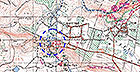
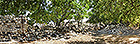
The mosque compound is part of the remains of the village of Hittin (حطين). The compound is situated at the foot of the Horns of Hittin ridge, on a moderate slope, north of which is the Arbel Valley. West of the building is a spring that flows into a narrow channel full of reeds. The channel reaches Nahal Nimra – a tributary of Nahal Arbel and the village cemetery is located nearby (Figure 1). The ruins of Hittin village are situated east of the mosque.
The purpose of the project was to document and perform a physical-engineering survey of the mosque compound, thereby establishing a basis of information that will be of assistance in conserving the structure.
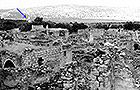
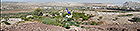
Laurence Oliphant (Haifa, 1976) visited the place in the late nineteenth century and described the spring and the village’s flourishing orchards. On the eve of the War of Independence the village population numbered 1,380 people but no one remained there following the conflict. In a survey carried out in 1966 (Figure 2) the village is described as a large settlement built over an area of fifteen dunams. The survey notes describe the nucleus of the ancient village where houses and courtyards were next to each other and two-three narrow streets separated the blocks of buildings. As the village expanded it was characterized by more spacious construction whereby each house had an adjacent courtyard and outbuildings.
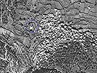
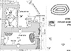
Historical aerial photographs show the access routes to the mosque, the surrounding farmland, and make it possible to trace the development of the village (Figure 3). The mosque compound comprises several buildings: a mosque composed of two spaces and a minaret, a separate lavatory, a rectangular structure built of cross vaults (now mostly destroyed) and a stone wall surrounding the compound.
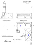
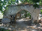
The mosque structure dates to the eighteenth century. It is surrounded by a courtyard in which there is a flowing spring and the remains of other buildings. The mosque consists of the following architectural elements: a minaret, a qibla wall that includes a mihrab designating the direction of prayer and remains of a minbar, that is, the pulpit adjacent to the mihrab. The ceiling is a pointed barrel vault. The entrance is fixed in the wall opposite the mihrab. To the right of the main entrance is a cross vault that is open to the east. The minaret is located on the western side of the mosque and is reached by way of an external staircase. A spiral staircase inside the minaret ascends to its top (Figure 4). At the top of the minaret are remains of iron bars that supported a railing around the balcony. This balcony was built of bossed stones connected by metal pins (clamps). The top of the minaret is truncated and on the basis of historical photographs it is unclear if it was adorned with the crescent emblem.
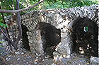
Four small plastered barrel vault stalls served as rectangular lavatories. The squatting type toilets were probably flushed clean by means of a shallow channel that conveyed water from the spring. In each of the toilet stalls are a small ventilation window and an opening in the floor fixed between two ashlar stones.
The peripheral wall reaches a height of 2.5 meters. The tallness of the wall is apparent in its corners and there are some sections along the wall that are dismantled (Figure 5).
Next to the compound’s northern wall is a stone building that is mostly destroyed. The piers of a pair of cross-vaults are all that remain of it. The structure is c. 10 meters long and has arched openings fixed in its northern and western walls.
The Cultural Significance of the Site
Historical Value
- The compound is tangible evidence of the Arab village of Hittin which was demolished in the 1960s. The bullet marks in the building’s walls are part of the history of the place and represent the Jewish-Arab conflict.
Architectural and Landscape Value
- Components characteristic of a Muslim religious structure were preserved in the mosque: the qibla wall, mihrab and minbar, minaret and source of water used in ablution.
- From a regional standpoint – the compound is located next to a hiking trail that runs from Nahal Namarim toward Nahal Arbel. The prominent minaret constitutes a landmark (Figure 6).
Social – Religious Value
- The mosque compound and nearby outbuildings are remains of a socio-religious compound that was used by the village inhabitants.
- In recent years the mosque has been used by Muslims who come to pray at the site.
- The maintenance work carried out in the compound attests to its emotional, religious and political importance.
State of Preservation
All of the structures are built according to traditional technology, utilizing limestone and lime-based mortar and plaster. In some of the compound’s buildings cement-based materials were used, indicative of intervention carried out in recent years. A roof described in the 1966 survey was made of tree trunks covered with tamped earth. Today the roof of the mosque is concrete covered with waterproof sheets sealed with tar in order to prevent water from penetrating into the building.
Some of the buildings in the compound are stable and some are in danger of collapse. Among other things, the mosque structure and peripheral wall suffer from cracking, missing mortar, lacunae in the cores of the walls, microbiology and bird-droppings that cause the stone and mortar to deteriorate and damage the colored plaster. Engineering failures, resulting from moisture, rain and the capillary action of water on the ground that is drawn up into the lower courses of stone have developed in these structures (Figure 7). Remains of the vaulted structure (Figure 8) and the lavatory (Figure 9) are in danger of collapse.
In conclusion, cracking, stone weathering and mortar missing from stone joints are evident in all of the structures. A real risk of collapse exists in those buildings where walls or piers have settled causing the ceiling to detach from the walls. The weathering and destructive processes occurring in these buildings can only be halted by conservation intervention.
List of Sources:
Olifant, L. 1882-1885. Haifa. Reprinted by Yad Ben Zvi, Jerusalem, 1976 (Hebrew).
Survey of the Arab Villages. Israel Antiquities Authority archive, 1966 (Hebrew).
The Survey of Israel, Department of Information and Land, Department of Aerial Photography.
To view the figures, click on the figure caption
|
|