| Burgin |
| Horbat Burgin |
| A Conservation and Development Plan for a Cultural Heritage Site |
| Orderer | KKL-JNF |
| Duration | Aug. 2012 - Jun. 2014 |
| Implemented by: |
Arch. Yaara Shaltiel
Landscape Arch. Ido Rosental
|
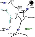
Horbat Burgin is situated in the middle of the Judean Shephelah, 7.5 km northeast of Bet Guvrin and c. 10.5 km south of Bet Shemesh (Fig. 1). The site is located at the center of ‘Adullam Park, which is administered by the Jewish National Fund.
Numerous antiquities robberies occurred at the site in recent decades prompting surveys and archaeological excavations that have resulted in the exposure of an impressive archaeological site. Horbat Burgin has tremendous tourism potential thanks to the many artifacts located there.
A small part of the site has been prepared for visitors in recent years. While ‘Adullam Park was still in the planning stage the Jewish National Fund decided to prepare a conservation and development program for the site. The plan for Horbat Burgin began taking shape in 2012 and was completed in June of 2014. The groundwork for the plan was based on: a summary of information about the site and its surroundings, documentation from the archaeological excavations and surveys conducted there, an analysis of the site’s components and their value, the formulation of planning principles and implementation phases, and finally the preparation of a planning program.
Historical Background
Three main settlement periods were documented at Horbat Burgin:
1. The Second Temple period to the Bar Kokhba revolt. The main finds are burial caves and subterranean hiding refuges.
2. The Byzantine period. The finds from this period include burial caves, pits used by religious recluses, a monastery and a church.
3. Late Ottoman period and the time of the British Mandate. Umm Burj village: architectural remains, fences and agricultural installations.
Throughout its history the settlement existed on the hilltop and its dead were buried along the slopes. Over time a necropolis formed like a broad ring enveloping the settlement and it reflects the various periods of habitation. The agricultural hinterland formed another peripheral ring around the necropolis.
Like many antiquities sites representing a habitation sequence, here too the secondary use of the ancient settlement remains is evident. With the development of the settlement above ground, changes also occurred in the usages below ground. Secondary use was made of the cisterns, burial caves and hiding refuges from the time of the Bar Kokhba revolt for monastic seclusion, storage, as quarries for raw material, as shelter for animals etc.
Importance of the Site
In ‘Adullam Park there are numerous remains of settlements and focal points of human activity from different periods. Some are known or are more easily accessible than those of Horbat Burgin. However, Horbat Burgin embodies historical, social and landscape values which thanks to them the site was deemed worthy of conservation and presentation to the public. The program seeks to highlight the site and use it to create an important attraction in the park.
Identifying Problems at the Park
Planning a site that is attractive to visitors at Horbat Burgin was by no means a simple task. Horbat Burgin is located deep within ‘Adullam Park, far from any main roads and the service installations in the archaeological center at the foot of Giv‘at Yeshayahu. At Burgin there are a large number of remains that differ in their size, degree of importance, state of preservation and accessibility. The existing trail “skips” between the sites and lacks a logical thread connecting them, such as chronological order, and many of the interesting remains are neither treated nor visited. Actually the most important aspect of the site – its unique and extensive necropolis – has attracted little attention. The underground cavities that are currently open to the public are more suitably entered by families and individuals and are less appropriate for guiding large groups. Large spaces should be prepared and made more suitable, as well as alternative subterranean visitor paths.
Planning Principles
An analysis of site’s components and their values made it possible to select interesting “key sites” that are representative of Horbat Burgin. The principles that guided the planning are as follows:
- Presenting the main historical periods in the development of the site with an emphasis on the Second Temple period and the Byzantine period through the use of “key sites” that aid to understanding them.
- Presenting the underground sites of the Second Temple period, including the necropolis and the hiding refuge complexes as a main topic in the development of the site.
- Emphasizing the ancient settlement as the center of the site, the necropolis as a secondary peripheral ring and agricultural hinterland as a tertiary peripheral ring.
- Highlighting the varied uses of the underground spaces during the historical periods.
- Creating circular trails of various degrees of difficulty. Each track will include at least one “key site” from each period.
- Planning the signage and the presentation of the sites will address the historical aspect, as well as topical issues such as the dilemma of conservation and antiquities robbery.
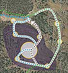
Planning the Visitor Trails. Three circular visitor trails were planned at the site: a short path 1.8 km long, a medium length path of 2.2 km and an extended path of 2.5 km. The three trails (Figure 2) pass through points of interest in the settlement, the necropolis (colored purple in the illustration) and the agricultural hinterland. The trails include vantage points and explanations allowing the visitor to get a good impression of Horbat Burgin (Figure 3).
In conclusion, the planning of Horbat Burgin is based on developing a number of “key sites” that embody the settlement history there. The program presents two main points of attraction: the ancient settlement above and especially below ground, and the large necropolis extending around it.
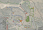
In order to expose the heritage of Horbat Burgin in an effective manner, the plan proposes three circular trails of different lengths (Figure 4), each of which passes through some of the key sites that chronologically tell the story of the place.
To view the figures, click on the figure caption
|
|